Africa is home to 55 countries, an ancient and complex history, modern cities, some 3,000 languages and over a billion people. From Algeria to Zimbabwe, here’s a snapshot of each country on a continent you need to know more about.

Rice fields and hillscapes encircle a village near Toamasina in the Atsinanana region of eastern Madagascar. (Mariusz Kluzniak, CC BY-NC-ND)
Jump to:
Africa

The iconic Blue Marble image of Earth was taken with a hand-held Hasselblad camera by a Nasa astronaut on the Apollo 17 mission to the moon in December 1972. In this, the most famous and often reproduced photo of our planet, Africa dominates. Africa is our second-largest continent, taking up over 20% – one-fifth – of the world’s land area.
Photo credit Nasa Earth Observatory
Surface area: 29,648,481 square kilometres
Population: 1.5 billion
Population density: 51.3 people per square kilometre
Gross domestic product (GDP): US$2.9-trillion
GDP per person: US$2,014
Annual carbon dioxide (CO2) emissions: 1.3 billion tonnes | 3.9% of world total
CO2 emissions per person: 0.9 tonnes | 0.2 x world average
Algeria
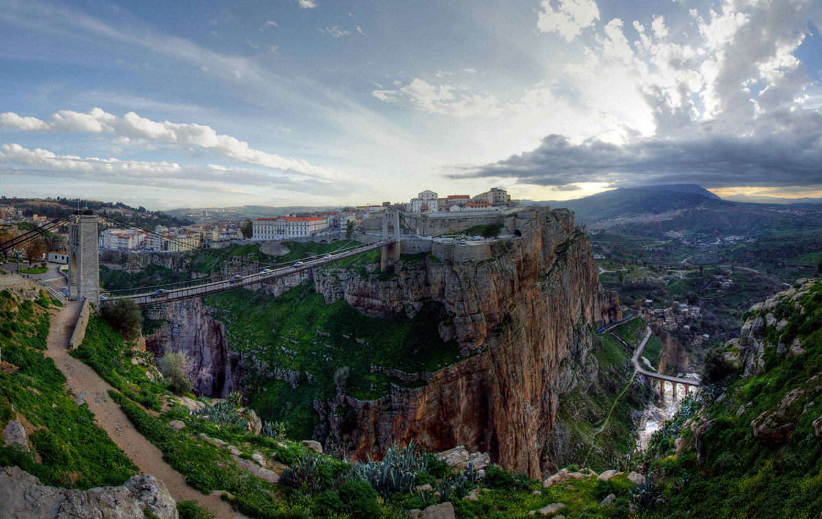
Dusk falls over Constantine, an ancient city on the Mediterranean coast of northern Algeria.
Photo credit Mariusz Kluzniak

ALGERIA: OVERVIEW
Region: Northern Africa
Population: 46.8 million | 3.1% of Africa’s population
Population density: 19.7 people per square kilometre | 0.4 x African average
Surface area: 2,381,741 square kilometres | 8% of Africa
Capital city: Algiers
ALGERIA: ECONOMY
World Bank classification: Upper middle income
Currency: Algerian dinar (DZD)
Gross domestic product (GDP): $191.9 billion | 6.7% of Africa’s GDP
Average GDP per person: $4,273.90 | 2.1 x African average
Agriculture: 13.3% of economy
Industry: 38% of economy
Services and other: 48.7% of economy
Labour force unemployment rate: 12.1%
Share of women in the labour force: 16.9%
Share of men in the labour force: 67.1%
ALGERIA: INTERNATIONAL TRADE
Major export partners (share of exports): Italy 26.5% | France 12.7% | Spain 11.7%
Major import partners (share of imports): China 22.4% | France 11.1% | Italy 7.2%
Exports value: $57.4 billion | 9.9% of Africa’s exports
Imports value: $44.6 billion | 6.5% of Africa’s imports
ALGERIA: INDICATORS
Income inequality – Gini index: 28.8% (2012) | Africa rank: 54th out of 54 (higher score & rank = more inequality)
Human development index: High | Score 0.763 | Africa rank: 3rd out of 54 | Global rank: 96th out of 193
Inequality-adjusted human development index: Score 0.601 | Africa rank: 3rd out of 51 | Global rank: 89th out of 169
Gender inequality index: Score 0.443 | Africa rank: 9th out of 49 | Global rank: 114th out of 172 (higher score = less equality; higher rank = more equality)
LGBT equality index: 13% | Africa rank: 35th out of 54 | Legal freedoms: 7% | Public opinion: 19%
Women in national parliament hold 7.9% of seats
Urbanisation: 73.2% of inhabitants live in cities
Internet access: 71.2% of inhabitants use the internet
ALGERIA: ENVIRONMENT
Forests: 0.8% of land area
Annual carbon dioxide (CO2) emissions: 146 million tonnes | 11.2% of African total | 0.4% of world total
CO2 emissions per person: 3.3 tonnes | 3.7 x African average | 0.8 x world average
ALGERIA: HISTORY & HERITAGE
Official languages: Arabic and Berber
Other languages: English and French
Colonised by: France 1830-1962
Independence: 1962 – from France
World Heritage Site: The Tassili n’Ajjer sandstone plateau in the Sahara is one of the richest prehistoric rock art sites in the world, with more than 15,000 rock paintings and engravings dated from 12,000 years ago to the first centuries of the common era.
Angola

Angola’s Serra da Leba high mountain pass lies at 1,845 metres (6,053 feet) above sea level in the province of Huíla, in the southeast of the country.
Photo credit JB Dodane

ANGOLA: OVERVIEW
Region: Middle Africa
Population: 37.9 million | 2.5% of Africa’s population
Population density: 30.4 people per square kilometre | 0.6 x African average
Surface area: 1,246,700 square kilometres | 4.2% of Africa
Capital city: Luanda
ANGOLA: ECONOMY
World Bank classification: Lower middle income
Currency: kwanza (AOA)
Gross domestic product (GDP): $113.3 billion | 3.9% of Africa’s GDP
Average GDP per person: $3,183.70 | 1.6 x African average
Agriculture: 13.7% of economy
Industry: 45.1% of economy
Services and other: 41.1% of economy
Labour force unemployment rate: 14.1%
Share of women in the labour force: 72.7%
Share of men in the labour force: 77.6%
ANGOLA: INTERNATIONAL TRADE
Major export partners (share of exports): China 42.7% | India 10% | France 7.1%
Major import partners (share of imports): China 16% | Portugal 10.7% | South Korea 9.2%
Exports value: $40.3 billion | 6.9% of Africa’s exports
Imports value: $22.1 billion | 3.2% of Africa’s imports
ANGOLA: INDICATORS
Income inequality – Gini index: 63.6% (2019) | Africa rank: 3rd out of 54 (higher score & rank = more inequality)
Human development index: Medium | Score 0.616 | Africa rank: 19th out of 54 | Global rank: 148th out of 193
Inequality-adjusted human development index: Score 0.36 | Africa rank: 27th out of 51 | Global rank: 142nd out of 169
Gender inequality index: Score 0.515 | Africa rank: 23rd out of 49 | Global rank: 139th out of 172 (higher score = less equality; higher rank = more equality)
LGBT equality index: 42% | Africa rank: 10th out of 54 | Legal freedoms: 50% | Public opinion: 35%
Urbanisation: 66.2% of inhabitants live in cities
Government spending on education: 2.1% of GDP
Women in national parliament hold 38.6% of seats
Internet access: 39.3% of inhabitants use the internet
ANGOLA: ENVIRONMENT
Forests: 53% of land area
Annual carbon dioxide (CO2) emissions: 14.5 million tonnes | 1.1% of African total | 0.04% of world total
CO2 emissions per person: 0.4 tonnes | 0.4 x African average | 0.1 x world average
ANGOLA: HISTORY & HERITAGE
Official language: Portuguese
Other languages: Kikongo, Chokwe, Umbundu, Kimbundu, Nganguela and Kwanyama
Colonised by: Portugal 1575-1975
Independence: 1975 – from Portugal
World Heritage site: M’banza Kongo, capital of the Kingdom of Kongo, which flourished as one of the largest states in southern Africa from the 14th to the 19th century.
Benin

In Possotomè, an arrondissement in the Mono department of Benin, a man takes part in the massive Vodun dance competition held every year by people from villages scattered along the shores of Lake Aheme.
Photo credit Adam Cohn
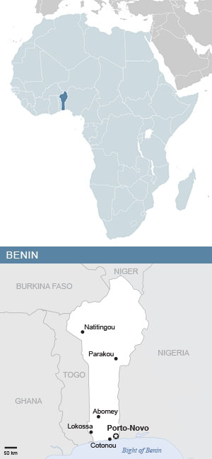
BENIN: OVERVIEW
Region: Western Africa
Population: 14.5 million | 1% of Africa’s population
Population density: 128.3 people per square kilometre | 2.5 x African average
Surface area: 114,763 square kilometres | 0.4% of Africa
Capital city: Porto-Novo
BENIN: ECONOMY
World Bank classification: Lower middle income
Currency: CFA franc, Central Bank of West African States (XOF)
Gross domestic product (GDP): $17.4 billion | 0.6% of Africa’s GDP
Average GDP per person: $1,302.90 | 0.6 x African average
Agriculture: 29.6% of economy
Industry: 18.7% of economy
Services and other: 51.6% of economy
Labour force unemployment rate: 1.4%
Share of women in the labour force: 56.8%
Share of men in the labour force: 68.8%
BENIN: INTERNATIONAL TRADE
Major export partners (share of exports): Bangladesh 37.2% | India 15.4% | Pakistan 7.2%
Major import partners (share of imports): India 17.1% | China 12.8% | France 8.6%
Exports value: $1.1 billion | 0.2% of Africa’s exports
Imports value: $3.9 billion | 0.6% of Africa’s imports
BENIN: INDICATORS
Income inequality – Gini index: 49.8% (2022) | Africa rank: 39th out of 54 (higher score & rank = more inequality)
Human development index: Low | Score 0.515 | Africa rank: 36th out of 54 | Global rank: 173rd out of 193
Inequality-adjusted human development index: Score 0.316 | Africa rank: 40th out of 51 | Global rank: 158th out of 169
Gender inequality index: Score 0.573 | Africa rank: 34th out of 49 | Global rank: 153rd out of 172 (higher score = less equality; higher rank = more equality)
LGBT equality index: 29% | Africa rank: 17th out of 54 | Legal freedoms: 42% | Public opinion: 16%
Urbanisation: 47.9% of inhabitants live in cities
Government spending on education: 3.2% of GDP
Women in national parliament hold 26.6% of seats
Internet access: 33.8% of inhabitants use the internet
BENIN: ENVIRONMENT
Forests: 27.4% of land area
Annual carbon dioxide (CO2) emissions: 5.4 million tonnes | 0.4% of African total | 0.02% of world total
CO2 emissions per person: 0.4 tonnes | 0.4 x African average | 0.1 x world average
BENIN: HISTORY & HERITAGE
Official language: French
Other languages: Fon and Yoruba
Colonised by: Portugal 1472-1892 | France 1892-1960
Independence: 1960 – from France
World Heritage Site: The Royal Palaces of Abomey, the seat of a dynasty of 12 kings who ruled the powerful Kingdom of Abomey from 1625 to 1900.
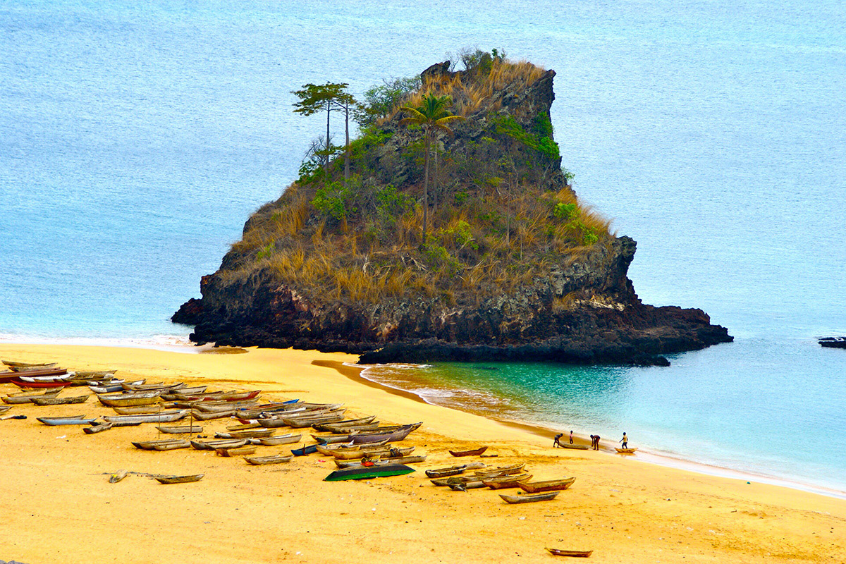
Botswana

Botswana’s Okavango Delta, a Unesco World Heritage Site, is one of the three largest inland deltas in the world, all found in Africa. It was once part of the ancient Lake Makgadikgadi, an inland sea that emptied out and dried up between 20,000 and 10,000 years ago.
Photo credit Pavel Špindler
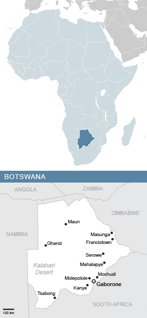
BOTSWANA: OVERVIEW
Region: Southern Africa
Population: 2.5 million | 0.2% of Africa’s population
Population density: 4.4 people per square kilometre | 0.09 x African average
Surface area: 582,000 square kilometres | 2% of Africa
Capital city: Gaborone
BOTSWANA: ECONOMY
World Bank classification: Upper middle income
Currency: pula (BWP)
Gross domestic product (GDP): $20.4 billion | 0.7% of Africa’s GDP
Average GDP per person: $7,737.70 | 3.8 x African average
Agriculture: 1.9% of economy
Industry: 39.4% of economy
Services and other: 58.8% of economy
Labour force unemployment rate: 23.5%
Share of women in the labour force: 59.8%
Share of men in the labour force: 69.3%
BOTSWANA: INTERNATIONAL TRADE
Major export partners (share of exports): United Arab Emirates 29.8% | Belgium 17.9% | India 12.3%
Major import partners (share of imports): South Africa 65% | Namibia 7.7% | Canada 4.9%
Exports value: $5.5 billion | 0.9% of Africa’s exports
Imports value: $6.4 billion | 0.9% of Africa’s imports
BOTSWANA: INDICATORS
Income inequality – Gini index: 56.9% (2016) | Africa rank: 16th out of 54 (higher score & rank = more inequality)
Human development index: High | Score 0.731 | Africa rank: 8th out of 54 | Global rank: 111th out of 193
Inequality-adjusted human development index: Score 0.509 | Africa rank: 8th out of 51 | Global rank: 110th out of 169
Gender inequality index: Score 0.49 | Africa rank: 14th out of 49 | Global rank: 127th out of 172 (higher score = less equality; higher rank = more equality)
LGBT equality index: 53% | Africa rank: 4th out of 54 | Legal freedoms: 54% | Public opinion: 51%
Urbanisation: 70.2% of inhabitants live in cities
Government spending on education: 8.1% of GDP
Women in national parliament hold 11.1% of seats
Internet access: 77.3% of inhabitants use the internet
BOTSWANA: ENVIRONMENT
Forests: 26.7% of land area
Annual carbon dioxide (CO2) emissions: 6.2 million tonnes | 0.5% of African total | 0.02% of world total
CO2 emissions per person: 2.4 tonnes | 2.7 x African average | 0.6 x world average
BOTSWANA: HISTORY & HERITAGE
Official language: English
Other languages: Setswana
Colonised by: Britain 1885-1966
Independence: 1966 – from Britain
World Heritage Site: Known as the ”Louvre of the Desert”, Tsodilo in the Kalahari Desert contains over 4,500 well-preserved rock paintings produced over the past 100,000 years.
Burkina Faso

The Grand Mosque in the city of Bobo-Dioulasso, in the southeast of Burkina Faso. Possibly the largest example of Sudano-Sahelian architecture in the country, the mosque was built in the 1880s as a part of political agreement between the king of Sya and Islamic religious leader Almamy Sidiki Sanou.
Photo credit QIV

BURKINA FASO: OVERVIEW
Region: Western Africa
Population: 23.5 million | 1.6% of Africa’s population
Population density: 86.1 people per square kilometre | 1.7 x African average
Surface area: 274,200 square kilometres | 0.9% of Africa
Capital city: Ouagadougou
BURKINA FASO: ECONOMY
World Bank classification: Low income
Currency: CFA franc, Central Bank of West African States (XOF)
Gross domestic product (GDP): $19.2 billion | 0.7% of Africa’s GDP
Average GDP per person: $845.80 | 0.4 x African average
Agriculture: 22.9% of economy
Industry: 33.7% of economy
Services and other: 43.4% of economy
Labour force unemployment rate: 4.9%
Share of women in the labour force: 57.3%
Share of men in the labour force: 72.6%
BURKINA FASO: INTERNATIONAL TRADE
Major export partners (share of exports): Switzerland 67.6% | United Arab Emirates 8.5% | Mali 6%
Major import partners (share of imports): Côte d’Ivoire 13.9% | China 13.7% | Russia 8.9%
Exports value: $4.5 billion | 0.8% of Africa’s exports
Imports value: $5.9 billion | 0.9% of Africa’s imports
BURKINA FASO: INDICATORS
Income inequality – Gini index: 52.5% (2022) | Africa rank: 33rd out of 54 (higher score & rank = more inequality)
Human development index: Low | Score 0.459 | Africa rank: 47th out of 54 | Global rank: 186th out of 193
Inequality-adjusted human development index: Score 0.273 | Africa rank: 46th out of 51 | Global rank: 164th out of 169
Gender inequality index: Score 0.555 | Africa rank: 29th out of 49 | Global rank: 146th out of 172 (higher score = less equality; higher rank = more equality)
LGBT equality index: 10% | Africa rank: 40th out of 54 | Legal freedoms: 10% | Public opinion: 10%
Urbanisation: 30% of inhabitants live in cities
Government spending on education: 5.2% of GDP
Women in national parliament hold 16.9% of seats
Internet access: 19.9% of inhabitants use the internet
BURKINA FASO: ENVIRONMENT
Forests: 22.5% of land area
Annual carbon dioxide (CO2) emissions: 5.2 million tonnes | 0.4% of African total | 0.02% of world total
CO2 emissions per person: 0.2 tonnes | 0.2 x African average | 0.05 x world average
BURKINA FASO: HISTORY & HERITAGE
Official language: French
Other languages: Mòoré, Fulani, Dioula
Colonised by: France 1896-1960
Independence: 1960 – from France
World Heritage Site: The 1,000-year-old Ruins of Loropéni, an imposing stone fortress that was the centre of the trans-Saharan gold trade from the 14th to 17th century.
Burundi
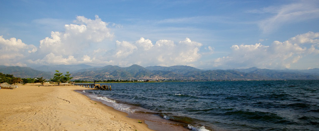
The shores of Lake Tanganyika with Burundi’s capital of Bujumbura in the distance.
Photo credit Michael Foley

BURUNDI: OVERVIEW
Region: Eastern Africa
Population: 14 million | 0.9% of Africa’s population
Population density: 541.3 people per square kilometre | 10.6 x African average
Surface area: 27,834 square kilometres | 0.09% of Africa
Capital city: Gitega
BURUNDI: ECONOMY
World Bank classification: Low income
Currency: Burundi franc (BIF)
Gross domestic product (GDP): $4 billion | 0.14% of Africa’s GDP
Average GDP per person: $312.90 | 0.2 x African average
Agriculture: 36.5% of economy
Industry: 19% of economy
Services and other: 44.7% of economy
Labour force unemployment rate: 0.8%
Share of women in the labour force: 78.8%
Share of men in the labour force: 78.8%
BURUNDI: INTERNATIONAL TRADE
Major export partners (share of exports): United Arab Emirates 28% | Democratic Republic of the Congo 18.6% | Switzerland 9.5%
Major import partners (share of imports): Saudi Arabia 14.7% | China 14.1% | United Arab Emirates 13.9%
Exports value: $183 million | 0.03% of Africa’s exports
Imports value: $1.2 billion | 0.2% of Africa’s imports
BURUNDI: INDICATORS
Income inequality – Gini index: 52.6% (2021) | Africa rank: 32nd out of 54 (higher score & rank = more inequality)
Human development index: Low | Score 0.439 | Africa rank: 48th out of 54 | Global rank: 187th out of 193
Inequality-adjusted human development index: Score 0.286 | Africa rank: 43rd out of 51 | Global rank: 161st out of 169
Gender inequality index: Score 0.501 | Africa rank: 18th out of 49 | Global rank: 132nd out of 172 (higher score = less equality; higher rank = more equality)
LGBT equality index: 10% | Africa rank: 40th out of 54 | Legal freedoms: 10% | Public opinion: 10%
Urbanisation: 13.4% of inhabitants live in cities
Government spending on education: 5.1% of GDP
Women in national parliament hold 38.2% of seats
Internet access: 11.3% of inhabitants use the internet
BURUNDI: ENVIRONMENT
Forests: 10.9% of land area
Annual carbon dioxide (CO2) emissions: 0.8 million tonnes | 0.06% of African total | 0.002% of world total
CO2 emissions per person: 0.1 tonnes | 0.1 x African average | 0.02 x world average
BURUNDI: HISTORY & HERITAGE
Official languages: French and Kurundi
Colonised by: Germany 1899-1916 | Belgium 1916-1962
Independence: 1962 – from Belgium
Heritage Site:: The royal domain of Gishora was founded by the Mwami Ntare Rugamba in the first half of the 19th century after its victory over the rebel leader Ntibirangwa.
Cabo Verde (Cape Verde)

The São Miguel region in northeastern part of Santiago, the largest island in the Cabo Verde archipelago.
Photo credit Rey Perezoso
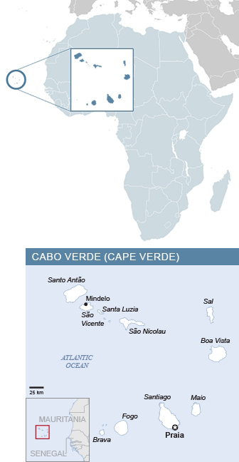
CABO VERDE: OVERVIEW
Region: Western Africa
Population: 525,000 | 0.3% of Africa’s population
Population density: 130.2 people per square kilometre | 2.5 x African average
Surface area: 4,033 square kilometres | 0.01% of Africa
Capital city: Praia
CABO VERDE: ECONOMY
World Bank classification: Upper middle income
Currency: Cape Verde escudo (CVE)
Gross domestic product (GDP): $2.3 billion | 0.08% of Africa’s GDP
Average GDP per person: $3,902.60 | 1.9 x African average
Agriculture: 4.3% of economy
Industry: 19.4% of economy
Services and other: 76.3% of economy
Labour force unemployment rate: 11.9%
Share of women in the labour force: 51.1%
Share of men in the labour force: 64.6%
CABO VERDE: INTERNATIONAL TRADE
Major export partners (share of exports): Spain 57.6%, Italy 20.1%, Portugal 18.8%
Major import partners (share of imports): Portugal 45.2%, Spain 8.6%, Togo 6.7%
Exports value: $49 million | 0.008% of Africa’s exports
Imports value: $928 million | 0.1% of Africa’s imports
CABO VERDE: INDICATORS
Income inequality – Gini index: 56.3% (2015) | Africa rank: 19th out of 54 (higher score & rank = more inequality)
Human development index: Medium | Score 0.668 | Africa rank: 13rd out of 54 | Global rank: 135th out of 193
Inequality-adjusted human development index: Score 0.478 | Africa rank: 9th out of 51 | Global rank: 116th out of 169
Gender inequality index: Score 0.298 | Africa rank: 3rd out of 49 | Global rank: 77th out of 172 (higher score = less equality; higher rank = more equality)
LGBT equality index: 68% | Africa rank: 1st out of 54 | Legal freedoms: 55% | Public opinion: 80%
Women in national parliament hold 38.9% of seats
Urbanisation: 66.2% of inhabitants live in cities
Government spending on education: 6.5% of GDP
Internet access: 72.1% of inhabitants use the internet
CABO VERDE: ENVIRONMENT
Forests: 11.4% of land area
Annual carbon dioxide (CO2) emissions: 600,000 tonnes | 0.05% of African total | 0.002% of world total
CO2 emissions per person: 1 tonne | 1.1 x African average | 0.2 x world average
CABO VERDE: HISTORY & HERITAGE
Official languages: Portuguese
Other languages: Cape Verdean Creole
Colonised by: Portugal 1462-1975
Independence: 1975 – from Portugal
World Heritage Site: Cidade Velha, built in the 1460s as the first European town in the tropics. The founding of the town marked a decisive step in Europe’s colonisation of Africa.
Cameroon

The Mandara Mountains near Rhumsiki in the Far North Province of Cameroon. Sixteen 15th-century archaeological sites have been identified in Mandara region. Known as Diy-gid-biy (or “place of chiefly residence”), these granite strongholds have been described as the most remarkable indigenous stone-built structures in sub-Saharan Africa outside the Horn and the southern African Zimbabwe complex.
Photo credit Krishna Naudin

CAMEROON: OVERVIEW
Region: Middle Africa
Population: 29.1 million | 1.9% of Africa’s population
Population density: 62.5 people per square kilometre | 1.2 x African average
Surface area: 475,650 square kilometres | 1.6% of Africa
Capital city: Yaoundé
CAMEROON: ECONOMY
World Bank classification: Lower middle income
Currency: CFA franc, Bank Of Central African States (XAF)
Gross domestic product (GDP): $44.3 billion | 1.5% of Africa’s GDP
Average GDP per person: $1,588.50 | 0.8 x African average
Agriculture: 18.3% of economy
Industry: 27.4% of economy
Services and other: 54.3% of economy
Labour force unemployment rate: 3.7%
Share of women in the labour force: 67.2%
Share of men in the labour force: 76.6%
CAMEROON: INTERNATIONAL TRADE
Major export partners (share of exports): China 25.9% | Netherlands 12.4% | India 9.7%
Major import partners (share of imports): China 17% | France 9% | India 7.2%
Exports value: $4.5 billion | 0.8% of Africa’s exports
Imports value: $8.9 billion | 1.3% of Africa’s imports
CAMEROON: INDICATORS
Income inequality – Gini index: 56.2% (2022) | Africa rank: 20th out of 54 (higher score & rank = more inequality)
Human development index: Medium | Score 0.588 | Africa rank: 23rd out of 54 | Global rank: 155th out of 193
Inequality-adjusted human development index: Score 0.361 | Africa rank: 25th out of 51 | Global rank: 140th out of 169
Gender inequality index: Score 0.558 | Africa rank: 30th out of 49 | Global rank: 149th out of 172 (higher score = less equality; higher rank = more equality)
LGBT equality index: 8% | Africa rank: 46th out of 54 | Legal freedoms: 4% | Public opinion: 11%
Urbanisation: 57% of inhabitants live in cities
Government spending on education: 2.8% of GDP
Women in national parliament hold 33.9% of seats
Internet access: 43.9% of inhabitants use the internet
CAMEROON: ENVIRONMENT
Forests: 42.9% of land area
Annual carbon dioxide (CO2) emissions: 6.5 million tonnes | 0.5% of African total | 0.02% of world total
CO2 emissions per person: 0.2 tonnes | 0.2 x African average | 0.05 x world average
CAMEROON: HISTORY & HERITAGE
Official languages: French and English
Other languages: 55 Afro-Asiatic languages, two Nilo-Saharan languages, 173 Niger-Congo languages, Camfranglais
Colonised by: Germany 1884-1916 | Britain 1916-1961 | France 1919-1960
Independence: 1960 – from France | 1961 – from Britain
World Heritage Site: The Dja Faunal Reserve is one of Africa’s largest and best-protected rain forests, almost completely surrounded by the Dja River and sheltering 107 mammal species, five of them threatened.
Central African Republic

The centre of Bangui, the capital of the Central African Republic. The Democratic Republic of the Congo is on the other side of the Oubangui river, at left.
Photo credit Alllexxxis

CENTRAL AFRICAN REPUBLIC: OVERVIEW
Region: Middle Africa
Population: 5.3 million | 0.4% of Africa’s population
Population density: 8.6 people per square kilometre | 0.2 x African average
Surface area: 622,984 square kilometres | 2.1% of Africa
Capital city: Bangui
CENTRAL AFRICAN REPUBLIC: ECONOMY
World Bank classification: Low income
Currency: CFA franc, Bank Of Central African States (XAF)
Gross domestic product (GDP): $2.4 billion | 0.08% of Africa’s GDP
Average GDP per person: $429.40 | 0.2 x African average
Agriculture: 33.4% of economy
Industry: 21.8% of economy
Services and other: 44.9% of economy
Labour force unemployment rate: 6.2%
Share of women in the labour force: 63.4%
Share of men in the labour force: 77.9%
CENTRAL AFRICAN REPUBLIC: INTERNATIONAL TRADE
Major export partners (share of exports): United Arab Emirates 40.9% | Pakistan 19.8% | Italy 12.6%
Major import partners (share of imports): Cameroon 40.2% | United States 9.7% | France 8.1%
Exports value: $127 million | 0.02% of Africa’s exports
Imports value: $543 million | 0.08% of Africa’s imports
CENTRAL AFRICAN REPUBLIC: INDICATORS
Income inequality – Gini index: 57.1% (2021) | Africa rank: 15th out of 54 (higher score & rank = more inequality)
Human development index: Low | Score 0.414 | Africa rank: 52nd out of 54 | Global rank: 191st out of 193
Inequality-adjusted human development index: Score 0.253 | Africa rank: 48th out of 51 | Global rank: 166th out of 169
LGBT equality index: 29% | Africa rank: 17th out of 54
Urbanisation: 41.8% of inhabitants live in cities
Government spending on education: 1.9% of GDP
Women in national parliament hold 11.4% of seats
Internet access: 7.5% of inhabitants use the internet
CENTRAL AFRICAN REPUBLIC: ENVIRONMENT
Forests: 35.8% of land area
Annual carbon dioxide (CO2) emissions: 0.2 million tonnes | 0.02% of African total | 0.0006% of world total
CO2 emissions per person: 0.04 tonnes | 0.04 x African average | 0.01 x world average
CENTRAL AFRICAN REPUBLIC: HISTORY & HERITAGE
Official languages: French and Sango
Colonised by: France 1894-1960
Independence: 1960 – from France
World Heritage Site: Manovo-Gounda St Floris National Park, whose importance of derives from its wealth of flora and fauna.
Chad

In northeastern Chad, nomads water their camels in the Guelta Archei on the Ennedi Plateau, a sandstone bulwark in the middle of the Sahara. A “guelta”, from Arabic, refers to a water source running at the bottom of the valley or canyon. (Image: © Hannes Rada

CHAD: OVERVIEW
Region: Middle Africa
Population: 20.3 million | 1.3% of Africa’s population
Population density: 16.1 people per square kilometre | 0.3 x African average
Surface area: 1,284,000 square kilometres | 4.3% of Africa
Capital city: N’Djamena
CHAD: ECONOMY
World Bank classification: Low income
Currency: CFA franc, Bank Of Central African States (XAF)
Gross domestic product (GDP): $16.8 billion | 0.6% of Africa’s GDP
Average GDP per person: $947.90 | 0.5 x African average
Agriculture: 29.7% of economy
Industry: 49% of economy
Services and other: 21.3% of economy
Labour force unemployment rate: 0.9%
Share of women in the labour force: 48.4%
Share of men in the labour force: 72.1%
CHAD: INTERNATIONAL TRADE
Major export partners (share of exports): United Arab Emirates 25.9% | China 20.7% | Germany 18.7%
Major import partners (share of imports): China 26.5% | United Arab Emirates 15.2% | Cameroon 11.8%
Exports value: $3.8 billion | 0.7% of Africa’s exports
Imports value: $1.4 billion | 0.2% of Africa’s imports
CHAD: INDICATORS
Income inequality – Gini index: 52.5% (2022) | Africa rank: 34th out of 54 (higher score & rank = more inequality)
Human development index: Low | Score 0.416 | Africa rank: 51st out of 54 | Global rank: 190th out of 193
Inequality-adjusted human development index: Score 0.252 | Africa rank: 49th out of 51 | Global rank: 167th out of 169
Gender inequality index: Score 0.67 | Africa rank: 47th out of 49 | Global rank: 169th out of 172 (higher score = less equality; higher rank = more equality)
LGBT equality index: 14% | Africa rank: 30th out of 54 | Legal freedoms: 14% | Public opinion: 14%
Urbanisation: 23.3% of inhabitants live in cities
Government spending on education: 2.9% of GDP
Women in national parliament hold 26.4% of seats
Internet access: 12.2% of inhabitants use the internet
CHAD: ENVIRONMENT
Forests: 3.3% of land area
Annual carbon dioxide (CO2) emissions: 2.2 million tonnes | 0.2% of African total | 0.007% of world total
CO2 emissions per person: 0.1 tonnes | 0.1 x African average | 0.02 x world average
CHAD: HISTORY & HERITAGE
Official languages: French and Arabic
Colonised by: France 1900-1960
Independence: 1960 – from France
World Heritage Site: The Lakes of Ounianga, a series of lakes in the Sahara Desert.
Comoros

The fishing harbour of Moroni on Grande Comore. Moroni is the capital of the island and of the Comoros archipelago. In the background is the Ancienne Mosquée de Vendredi (Old Friday Mosque), built in 1427.
Photo credit IWRM AIO SIDS

COMOROS: OVERVIEW
Region: Eastern Africa
Population: 867,000 | 0.06% of Africa’s population
Population density: 465.7 people per square kilometre | 9.1 x African average
Surface area: 2,235 square kilometres | 0.008% of Africa
Capital city: Moroni
COMOROS: ECONOMY
World Bank classification: Lower middle income
Currency: Comorian franc (KMF)
Gross domestic product (GDP): $1.2 billion | 0.04% of Africa’s GDP
Average GDP per person: $1,489.80 | 0.7 x African average
Agriculture: 38% of economy
Industry: 9.5% of economy
Services and other: 52.5% of economy
Labour force unemployment rate: 5.6%
Share of women in the labour force: 33.1%
Share of men in the labour force: 55.4%
COMOROS: INTERNATIONAL TRADE
Major export partners (share of exports): India 24.8% | Tanzania 21.4% | France 19.6%
Major import partners (share of imports): United Arab Emirates 44.1% | France 11.3% | Pakistan 9.7%
Exports value: $54 million | 0.009% of Africa’s exports
Imports value: $387 million | 0.06% of Africa’s imports
COMOROS: INDICATORS
Income inequality – Gini index: 58.7% (2014) | Africa rank: 9th out of 54 (higher score & rank = more inequality)
Human development index: Medium | Score 0.603 | Africa rank: 20th out of 54 | Global rank: 152nd out of 193
Inequality-adjusted human development index: Score 0.356 | Africa rank: 29th out of 51 | Global rank: 144th out of 169
Gender inequality index: Score 0.501 | Africa rank: 18th out of 49 | Global rank: 132nd out of 172 (higher score = less equality; higher rank = more equality)
LGBT equality index: 17% | Africa rank: 26th out of 54 | Legal freedoms: 15% | Public opinion: 19%
Urbanisation: 29.2% of inhabitants live in cities
Government spending on education: 2.5% of GDP
Women in national parliament hold 16.7% of seats
Internet access: 16.4% of inhabitants use the internet
COMOROS: ENVIRONMENT
Forests: 17.5% of land area
Annual carbon dioxide (CO2) emissions: 0.5 million tonnes | 0.04% of African total | 0.002% of world total
CO2 emissions per person: 0.6 tonnes | 0.7 x African average | 0.14 x world average
COMOROS: HISTORY & HERITAGE
Official languages: Comorian, Arabic and French
Colonised by: France 1841-1975
Independence: 1975 – from France
Congo, Democratic Republic (DRC)

A view of the twin Congo capitals, facing each other across the Congo River. In this 2003 photo taken from the International Space Station, the smaller city of Brazzaville, capital of the Republic of the Congo, is at upper left. The much larger grey area at lower left is Kinshasa, capital of the Democratic Republic of the Congo. The cities lie at the point where the Congo River becomes navigable upstream, widening to the east into Pool Malebo – previously named Stanley Pool, in honour of himself, by the brutal 19th century British-American explorer Henry Morton Stanley, who prospected the region on behalf of King Leopold II of Belgium.
Photo credit Nasa Earth Observatory

DRC: OVERVIEW
Region: Middle Africa
Population: 109.3 million | 7.2% of Africa’s population
Population density: 48.2 people per square kilometre | 0.9 x African average
Surface area: 2,345,410 square kilometres | 7.9% of Africa
Capital city: Kinshasa
DRC: ECONOMY
World Bank classification: Low income
Currency: Congolese franc (CDF)
Gross domestic product (GDP): $62.6 billion | 2.2% of Africa’s GDP
Average GDP per person: $631.80 | 0.3 x African average
Agriculture: 17.9% of economy
Industry: 49.8% of economy
Services and other: 32.3% of economy
Labour force unemployment rate: 4.5%
Share of women in the labour force: 62.6%
Share of men in the labour force: 68.9%
DRC: INTERNATIONAL TRADE
Major export partners (share of exports): China 47.1% | Singapore 8.7% | China, Hong Kong SAR 7.9%
Major import partners (share of imports): China 26.5% | South Africa 11.5% | United Arab Emirates 10%
Exports value: $15 billion | 2.6% of Africa’s exports
Imports value: $13.5 billion | 2% of Africa’s imports
DRC: INDICATORS
Income inequality – Gini index: 58.5% (2020) | Africa rank: 10th out of 54 (higher score & rank = more inequality)
Human development index: Low | Score 0.522 | Africa rank: 34th out of 54 | Global rank: 171st out of 193
Inequality-adjusted human development index: Score 0.341 | Africa rank: 31st out of 51 | Global rank: 146th out of 169
Gender inequality index: Score 0.604 | Africa rank: 42nd out of 49 | Global rank: 162nd out of 172 (higher score = less equality; higher rank = more equality)
LGBT equality index: 22% | Africa rank: 23rd out of 54 | Legal freedoms: 35% | Public opinion: 8%
Urbanisation: 45% of inhabitants live in cities
Government spending on education: 2.7% of GDP
Women in national parliament hold 12.8% of seats
Internet access: 27.2% of inhabitants use the internet
DRC: ENVIRONMENT
Forests: 55.2% of land area
Annual carbon dioxide (CO2) emissions: 3.3 million tonnes | 0.3% of African total | 0.01% of world total
CO2 emissions per person: 0.04 tonnes | 0.04 x African average | 0.01 x world average
DRC: HISTORY & HERITAGE
Official language: French
Other languages: Lingala, Kikongo, Swahili, Tshiluba
Colonised by: King Leopold II of Belgium (as his private property) 1877-1908 | Belgium 1908-1960
Independence: 1960 – from Belgium
World Heritage Site: The 490,000-hectare Garamba National Park covers vast grass savannahs and woodlands interspersed with gallery forests and marshland.
Congo, Republic

The Basilica of Saint Anne in Brazzaville, the capital of the Republic of the Congo, is a Catholic church built in the 1940s using a mix of European and African design styles. The massive green-tiled building is 85 metres long, with a transept 45 metres wide and a 22-metre-high arch.
Photo © Tom Robertson

CONGO REPUBLIC: OVERVIEW
Region: Middle Africa
Population: 6.3 million | 0.4% of Africa’s population
Population density: 18.5 people per square kilometre | 0.4 x African average
Surface area: 342,000 square kilometres | 1.2% of Africa
Capital city: Brazzaville
CONGO REPUBLIC: ECONOMY
World Bank classification: Lower middle income
Currency: CFA franc, Bank Of Central African States (XAF)
Gross domestic product (GDP): $15.3 billion | 0.5% of Africa’s GDP
Average GDP per person: $2,570.10 | 1.3 x African average
Agriculture: 8.9% of economy
Industry: 44% of economy
Services and other: 47.1% of economy
Labour force unemployment rate: 19.5%
Share of women in the labour force: 66.9%
Share of men in the labour force: 68.8%
CONGO REPUBLIC: INTERNATIONAL TRADE
Major export partners (share of exports): China 45.8% | Côte d’Ivoire 8.6% | Togo 7.5%
Major import partners (share of imports): China 19.6% | France 12.5% | Belgium 9%
Exports value: $4.6 billion | 0.8% of Africa’s exports
Imports value: $3.6 billion | 0.5% of Africa’s imports
CONGO REPUBLIC: INDICATORS
Income inequality – Gini index: 61.7% (2012) | Africa rank: 7th out of 54 (higher score & rank = more inequality)
Human development index: Medium | Score 0.649 | Africa rank: 15th out of 54 | Global rank: 138th out of 193
Inequality-adjusted human development index: Score 0.426 | Africa rank: 15th out of 51 | Global rank: 128th out of 169
Gender inequality index: Score 0.565 | Africa rank: 32nd out of 49 | Global rank: 151st out of 172 (higher score = less equality; higher rank = more equality)
LGBT equality index: 30% | Africa rank: 16th out of 54 | Legal freedoms: 44% | Public opinion: 17%
Urbanisation: 67.4% of inhabitants live in cities
Government spending on education: 3.9% of GDP
Women in national parliament hold 14.6% of seats
Internet access: 36.2% of inhabitants use the internet
CONGO REPUBLIC: ENVIRONMENT
Forests: 64.2% of land area
Annual carbon dioxide (CO2) emissions: 4.3 million tonnes | 0.3% of African total | 0.01% of world total
CO2 emissions per person: 0.7 tonnes | 0.8 x African average | 0.17 x world average
CONGO REPUBLIC: HISTORY & HERITAGE
Official language: French
Other languages: Kituba, Lingala
Colonised by: France 1880-1960
Independence: 1960 – from France
Côte d’Ivoire (Ivory Coast)

An aerial view of the district of Plateau in the Côte d’Ivoire capital of Abidjan.
Photo credit Basile Zoma, UN Photo

CÔTE D’IVOIRE: OVERVIEW
Region: Western Africa
Population: 31.9 million | 2.1% of Africa’s population
Population density: 100.4 people per square kilometre | 2 x African average
Surface area: 322,462 square kilometres | 1.1% of Africa
Capital city: Yamoussoukro
CÔTE D’IVOIRE: ECONOMY
World Bank classification: Lower middle income
Currency: CFA franc, Central Bank of West African States (XOF)
Gross domestic product (GDP): $70 billion | 2.4% of Africa’s GDP
Average GDP per person: $2,486.40 | 1.2 x African average
Agriculture: 17.8% of economy
Industry: 24.2% of economy
Services and other: 58% of economy
Labour force unemployment rate: 2.4%
Share of women in the labour force: 56.5%
Share of men in the labour force: 72.2%
CÔTE D’IVOIRE: INTERNATIONAL TRADE
Major export partners (share of exports): Mali 8.9% | Netherlands 8.7% | Switzerland 8.1%
Major import partners (share of imports): China 14.4% | Nigeria 12.1% | France 6.7%
Exports value: $8.9 billion | 1.5% of Africa’s exports
Imports value: $19.7 billion | 2.9% of Africa’s imports
CÔTE D’IVOIRE: INDICATORS
Income inequality – Gini index: 54.5% (2022) | Africa rank: 25th out of 54 (higher score & rank = more inequality)
Human development index: Medium | Score 0.582 | Africa rank: 24th out of 54 | Global rank: 157th out of 193
Inequality-adjusted human development index: Score 0.35 | Africa rank: 30th out of 51 | Global rank: 145th out of 169
Gender inequality index: Score 0.589 | Africa rank: 39th out of 49 | Global rank: 159th out of 172 (higher score = less equality; higher rank = more equality)
LGBT equality index: 25% | Africa rank: 21st out of 54 | Legal freedoms: 35% | Public opinion: 14%
Urbanisation: 51.2% of inhabitants live in cities
Government spending on education: 3.5% of GDP
Women in national parliament hold 13.4% of seats
Internet access: 38.4% of inhabitants use the internet
CÔTE D’IVOIRE: ENVIRONMENT
Forests: 8.6% of land area
Annual carbon dioxide (CO2) emissions: 13.8 million tonnes | 1.1% of African total | 0.04% of world total
CO2 emissions per person: 0.5 tonnes | 0.6 x African average | 0.12 x world average
CÔTE D’IVOIRE: HISTORY & HERITAGE
Official language: French
Other languages: Baoulé, Sénoufo, Yacouba, Agni, Attié, Guéré, Bété, Dioula, Abé, Mahou, Wobé, Lobi and others
Colonised by: France 1893-1960
Independence: 1960 – from France
World Heritage Site: The historic town of Grand-Bassam, the first capital of Côte d’Ivoire, is an example of a late 19th-century colonial town planned with quarters specialising in commerce, administration, and different housing for Europeans and Africans.
Djibouti
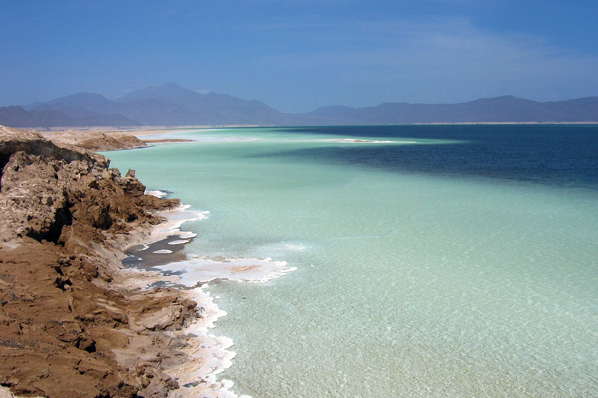
Lake Assal, a crater lake in the Afar Triangle, lies on the northern tip of the Great Rift Valley. At 155 metres (509 feet) below sea level, the lake is the lowest point on land in Africa and the third-lowest on Earth after the Dead Sea and Sea of Galilee. With no water outflow, the lake is 10 times more saline than the sea, the second most saline body of water on the planet, and holds the world’s largest salt reserve.
Photo credit Fishercd, Wikimedia Commons
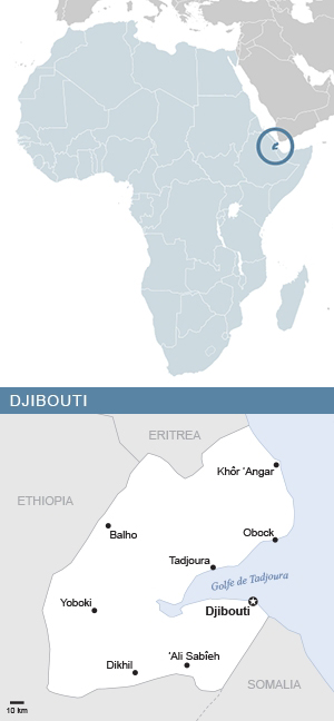
DJIBOUTI: OVERVIEW
Region: Eastern Africa
Population: 1.2 million | 0.08% of Africa’s population
Population density: 50.4 people per square kilometre | 1 x African average
Surface area: 23,200 square kilometres | 0.08% of Africa
Capital city: Djibouti
DJIBOUTI: ECONOMY
World Bank classification: Lower middle income
Currency: Djibouti franc (DJF)
Gross domestic product (GDP): $4 billion | 0.14% of Africa’s GDP
Average GDP per person: $3,571.80 | 1.8 x African average
Agriculture: 1.4% of economy
Industry: 12% of economy
Services and other: 86.6% of economy
Labour force unemployment rate: 26%
Share of women in the labour force: 18.5%
Share of men in the labour force: 46.1%
DJIBOUTI: INTERNATIONAL TRADE
Major export partners (share of exports): China 38.6% | United States 15.6% | India 11.5%
Major import partners (share of imports): China 31.4% | Saudi Arabia 19.2% | United Arab Emirates 15.3%
Exports value: $468 million | 0.08% of Africa’s exports
Imports value: $1.8 billion | 0.3% of Africa’s imports
DJIBOUTI: INDICATORS
Income inequality – Gini index: 45% (2017) | Africa rank: 45th out of 54 (higher score & rank = more inequality)
Human development index: Low | Score 0.513 | Africa rank: 38th out of 54 | Global rank: 175th out of 193
Inequality-adjusted human development index: Score 0.341 | Africa rank: 31st out of 51 | Global rank: 146th out of 169
Gender inequality index: Score 0.481 | Africa rank: 12nd out of 49 | Global rank: 122nd out of 172 (higher score = less equality; higher rank = more equality)
LGBT equality index: 35% | Africa rank: 13rd out of 54
Urbanisation: 77.9% of inhabitants live in cities
Government spending on education: 3.8% of GDP
Women in national parliament hold 26.2% of seats
Internet access: 65% of inhabitants use the internet
DJIBOUTI: ENVIRONMENT
Forests: 0.3% of land area
Annual carbon dioxide (CO2) emissions: 0.4 million tonnes | 0.03% of African total | 0.001% of world total
CO2 emissions per person: 0.4 tonnes | 0.4 x African average | 0.1 x world average
DJIBOUTI: HISTORY & HERITAGE
Official languages: French, Arabic
Other languages: Somali, Afar
Colonised by: France 1894-1977
Independence: 1977 – from France
National heritage site: The Abourma petroglyphs, several thousand Neolithic images carved in cave walls depicting humans, wildlife, hunting and warfare, dating back to 3,000 BCE.
Egypt
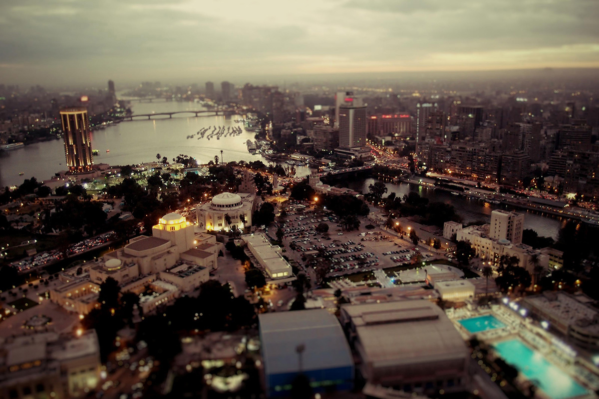
A view of the Nile River and Egypt’s capital city of Cairo from the Cairo Tower at sunset.
Photo credit Ville Miettinen

EGYPT: OVERVIEW
Region: Northern Africa
Population: 116.5 million | 7.7% of Africa’s population
Population density: 117.1 people per square kilometre | 2.3 x African average
Surface area: 1,002,000 square kilometres | 3.4% of Africa
Capital city: Cairo
EGYPT: ECONOMY
World Bank classification: Lower middle income
Currency: Egyptian pound (EGP)
Gross domestic product (GDP): $409.3 billion | 14.3% of Africa’s GDP
Average GDP per person: $3,687.80 | 1.8 x African average
Agriculture: 11.5% of economy
Industry: 34.4% of economy
Services and other: 54.1% of economy
Labour force unemployment rate: 6.3%
Share of women in the labour force: 16.5%
Share of men in the labour force: 71.3%
EGYPT: INTERNATIONAL TRADE
Major export partners (share of exports): Türkiye 9% | Italy 7.5% | Saudi Arabia 6.4%
Major import partners (share of imports): China 15.6% | United States 6.5% | Saudi Arabia 6.3%
Exports value: $42.1 billion | 7.2% of Africa’s exports
Imports value: $83.2 billion | 12.1% of Africa’s imports
EGYPT: INDICATORS
Income inequality – Gini index: 35.6% (2018) | Africa rank: 51st out of 54 (higher score & rank = more inequality)
Human development index: High | Score 0.754 | Africa rank: 4th out of 54 | Global rank: 100th out of 193
Inequality-adjusted human development index: Score 0.582 | Africa rank: 5th out of 51 | Global rank: 98th out of 169
Gender inequality index: Score 0.398 | Africa rank: 7th out of 49 | Global rank: 101st out of 172 (higher score = less equality; higher rank = more equality)
LGBT equality index: 10% | Africa rank: 40th out of 54 | Legal freedoms: 5% | Public opinion: 15%
Urbanisation: 42.7% of inhabitants live in cities
Government spending on education: 3.9% of GDP
Women in national parliament hold 27.7% of seats
Internet access: 72.2% of inhabitants use the internet
EGYPT: ENVIRONMENT
Forests: 0.04% of land area
Annual carbon dioxide (CO2) emissions: 227.7 million tonnes | 17.5% of African total | 0.7% of world total
CO2 emissions per person: 2.1 tonnes | 2.3 x African average | 0.5 x world average
EGYPT: HISTORY & HERITAGE
Official languages: Arabic
Other languages: Egyptian Arabic
Colonised by: Britain 1882-1952
Independence: 1952 – from Britain
World Heritage Site: Ancient Thebes, with its temples and palaces at Karnak and Luxor, and the necropolises of the Valley of the Kings and the Valley of the Queens, is a striking testimony to Egyptian civilization at its height.
Equatorial Guinea
Fishing boats, beach and rock formation on Annobón Island. Equatorial Guinea is made up of three geographic parts: the mainland on the African continent, the island of Bioko in the Gulf of Guinea, and Annobón, a small volcanic island south of the equator.
Photo credit Embassy of Equatorial Guinea

EQUATORIAL GUINEA: OVERVIEW
Region: Middle Africa
Population: 1.9 million | 0.1% of Africa’s population
Population density: 67.5 people per square kilometre | 1.3 x African average
Surface area: 28,052 square kilometres | 0.09% of Africa
Capital city: Malabo
EQUATORIAL GUINEA: ECONOMY
World Bank classification: Upper middle income
Currency: CFA franc, Bank Of Central African States (XAF)
Gross domestic product (GDP): $11.8 billion | 0.4% of Africa’s GDP
Average GDP per person: $7,025.70 | 3.5 x African average
Agriculture: 2.6% of economy
Industry: 52.8% of economy
Services and other: 44.7% of economy
Labour force unemployment rate: 8.5%
Share of women in the labour force: 51.7%
Share of men in the labour force: 59.5%
EQUATORIAL GUINEA: INTERNATIONAL TRADE
Major export partners (share of exports): China 22.7% | India 13% | Netherlands 10.5%
Major import partners (share of imports): China 17.7% | Spain 14.6% | Gabon 12.7%
Exports value: $4.7 billion | 0.8% of Africa’s exports
Imports value: $1.1 billion | 0.2% of Africa’s imports
EQUATORIAL GUINEA: INDICATORS
Income inequality – Gini index: 54.4% (2006) | Africa rank: 26th out of 54 (higher score & rank = more inequality)
Human development index: Medium | Score 0.674 | Africa rank: 12nd out of 54 | Global rank: 133rd out of 193
LGBT equality index: 38% | Africa rank: 11th out of 54
Urbanisation: 72.6% of inhabitants live in cities
Government spending on education: 0.3% of GDP
Women in national parliament hold 32% of seats
Internet access: 66.8% of inhabitants use the internet
EQUATORIAL GUINEA: ENVIRONMENT
Forests: 87% of land area
Annual carbon dioxide (CO2) emissions: 6.8 million tonnes | 0.5% of African total | 0.02% of world total
CO2 emissions per person: 4.2 tonnes | 4.7 x African average | 1 x world average
EQUATORIAL GUINEA: HISTORY & HERITAGE
Official languages: Spanish, French, Portuguese
Other languages: Fang, Bube, Combe, West African Pidgin English, Annobonese, Igbo
Colonised by: Portugal 1472-1778 | Spain 1778-1968
Independence: 1968 – from Spain
National heritage site: Iron Age burial sites on the Island of Corisco, also known as Mandji, with intact 1,500-year-old tombs containing artefacts such as axes, spears, anklets, bracelets and unbroken pots.
Eritrea

A man looks out from a carriage on the Eritrean railway line between the capital of Asmara and the coastal city of Massawa. Built between between 1887 and 1932, Eritrea’s rail system still uses vintage rolling stock.
Photo credit Andrea Moroni

ERITREA: OVERVIEW
Region: Eastern Africa
Population: 3.8 million | 0.3% of Africa’s population
Population density: 31.9 people per square kilometre | 0.6 x African average
Surface area: 117,600 square kilometres | 0.4% of Africa
Capital city: Asmara
ERITREA: ECONOMY
World Bank classification: Low income
Currency: Nakfa (ERN)
Gross domestic product (GDP): $2.3 billion | 0.08% of Africa’s GDP
Average GDP per person: $594.50 | 0.3 x African average
Agriculture: 17.1% of economy
Industry: 21.6% of economy
Services and other: 61.2% of economy
Labour force unemployment rate: 6.5%
Share of women in the labour force: 39.1%
Share of men in the labour force: 79.5%
ERITREA: INTERNATIONAL TRADE
Major export partners (share of exports): China 45.9% | United Arab Emirates 39.7% | South Korea 9.6%
Major import partners (share of imports): China 31.8% | United Arab Emirates 24.8% | Türkiye 9%
Exports value: $620.4 million | 0.1% of Africa’s exports
Imports value: $1.2 billion | 0.2% of Africa’s imports
ERITREA: INDICATORS
Income inequality – Gini index: 54.7% (1997) | Africa rank: 24th out of 54 (higher score & rank = more inequality)
Human development index: Low | Score 0.503 | Africa rank: 41st out of 54 | Global rank: 178th out of 193
LGBT equality index: 5% | Africa rank: 51st out of 54
Urbanisation: 41.1% of inhabitants live in cities
Government spending on education: 3.0% of GDP
Women in national parliament hold 22% of seats
Internet access: 8.3% of inhabitants use the internet
ERITREA: ENVIRONMENT
Forests: 15% of land area
Annual carbon dioxide (CO2) emissions: 1.4 million tonnes | 0.1% of African total | 0.004% of world total
CO2 emissions per person: 0.3 tonnes | 0.3 x African average | 0.1 x world average
ERITREA: HISTORY & HERITAGE
Languages: Tigrinya, Arabic, Tigre, Kunama, Saho, Bilen, Nara, Afar, English
Colonised by: Italy 1880-1941 | Britain 1941-1952 | Ethiopia 1952-1991
Independence: 1952 – from Britain | 1991 – from Ethiopia
World Heritage Site: The historic perimeter of Asmara represents perhaps the most concentrated and intact assemblage of Modernist architecture in the world. Its urban design has remained untouched since the 1930s.
Eswatini (formerly Swaziland)
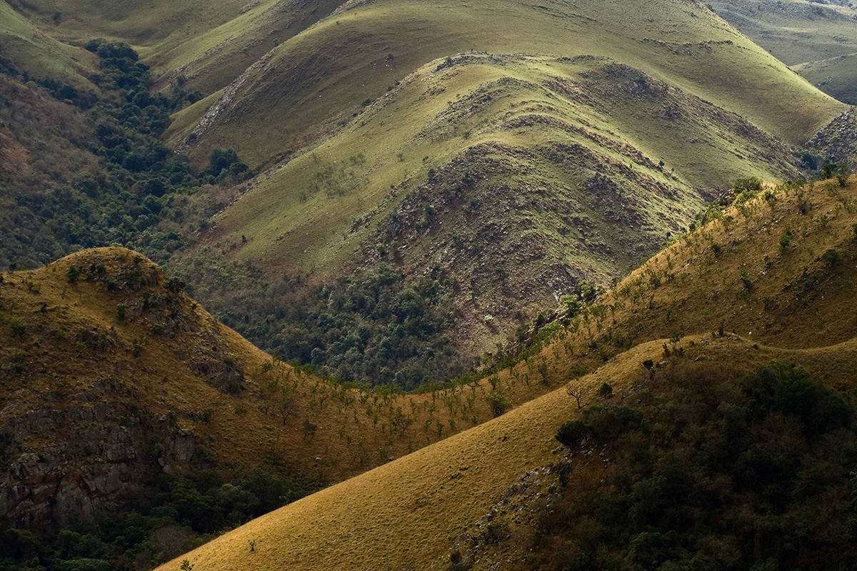
Hillscape in the Malolotja Nature Reserve, Eswatini.
Photo credit Julien Lagarde
Note: In 2018 the country changed its name from Swaziland, a relic of British colonialism, to Eswatini (sometimes spelled eSwatini).

ESWATINI: OVERVIEW
Region: Southern Africa
Population: 1.2 million | 0.08% of Africa’s population
Population density: 69.4 people per square kilometre | 1.4 x African average
Surface area: 17,364 square kilometres | 0.06% of Africa
Capital city: Mbabane (administrative)
ESWATINI: ECONOMY
World Bank classification: Lower middle income
Currency: Lilangeni (SZL)
Gross domestic product (GDP): $4.7 billion | 0.2% of Africa’s GDP
Average GDP per person: $3,458.60 | 1.7 x African average
Agriculture: 6.4% of economy
Industry: 46.1% of economy
Services and other: 47.5% of economy
Labour force unemployment rate: 24.4%
Share of women in the labour force: 48.3%
Share of men in the labour force: 62.9%
ESWATINI: INTERNATIONAL TRADE
Major export partners (share of exports): South Africa 67.9% | Kenya 5.6% | Nigeria 3.9%
Major import partners (share of imports): South Africa 72.4% | China 9.7% | India 2.7%
Exports value: $2.0 billion | 0.3% of Africa’s exports
Imports value: $1.8 billion | 0.3% of Africa’s imports
ESWATINI: INDICATORS
Income inequality – Gini index: 66.3% (2017) | Africa rank: 2nd out of 54 (higher score & rank = more inequality)
Human development index: Medium | Score 0.695 | Africa rank: 11th out of 54 | Global rank: 126th out of 193
Inequality-adjusted human development index: Score 0.431 | Africa rank: 14th out of 51 | Global rank: 127th out of 169
Gender inequality index: Score 0.484 | Africa rank: 13rd out of 49 | Global rank: 124th out of 172 (higher score = less equality; higher rank = more equality)
LGBT equality index: 28% | Africa rank: 19th out of 54 | Legal freedoms: 28% | Public opinion: 27%
Urbanisation: 24.7% of inhabitants live in cities
Government spending on education: 6.4% of GDP
Women in national parliament hold 23% of seats
Internet access: 31.3% of inhabitants use the internet
ESWATINI: ENVIRONMENT
Forests: 32% of land area
Annual carbon dioxide (CO2) emissions: 1.3 million tonnes | 0.1% of African total | 0.004% of world total
CO2 emissions per person: 1.1 tonnes | 1.2 x African average | 0.3 x world average
ESWATINI: HISTORY & HERITAGE
Official languages: siSwati, English
Colonised by: Britain 1906-1968
Independence: 1968 – from Britain
National heritage site: Ngwenya Mine is the site of the world’s earliest mining activity, and its iron ore deposits one of the oldest geological formations in the world.
Ethiopia

Fasilides Castle in the walled Fasil Ghebbi fortress of Gondar, a city in northern Ethiopia. The fortress was built at the behest of Fasilides, emperor of Ethiopia from 1632 to 18 October 1667.
Photo credit Eric Fortin

ETHIOPIA: OVERVIEW
Region: Eastern Africa
Population: 129.5 million | 8.6% of Africa’s population
Population density: 120.0 people per square kilometre | 2.3 x African average
Surface area: 1,104,300 square kilometres | 3.7% of Africa
Capital city: Addis Ababa
ETHIOPIA: ECONOMY
World Bank classification: Not classified
Currency: Birr (ETB)
Gross domestic product (GDP): $156.1 billion | 5.4% of Africa’s GDP
Average GDP per person: $1,206.20 | 0.6 x African average
Agriculture: 34.0% of economy
Industry: 23.0% of economy
Services and other: 43.0% of economy
Labour force unemployment rate: 4.8%
Share of women in the labour force: 78.7%
Share of men in the labour force: 89.1%
ETHIOPIA: INTERNATIONAL TRADE
Major export partners (share of exports):
Major import partners (share of imports):
Exports value: $4.1 billion | 0.7% of Africa’s exports
Imports value: $14.2 billion | 2.1% of Africa’s imports
ETHIOPIA: INDICATORS
Income inequality – Gini index: 50.6% (2016) | Africa rank: 38th out of 54 (higher score & rank = more inequality)
Human development index: Low | Score 0.497 | Africa rank: 43rd out of 54 | Global rank: 180th out of 193
Inequality-adjusted human development index: Score 0.326 | Africa rank: 37th out of 51 | Global rank: 153rd out of 169
Gender inequality index: Score 0.497 | Africa rank: 17th out of 49 | Global rank: 131st out of 172 (higher score = less equality; higher rank = more equality)
LGBT equality index: 12% | Africa rank: 39th out of 54 | Legal freedoms: 10% | Public opinion: 13%
Urbanisation: 23.2% of inhabitants live in cities
Government spending on education: 4.5% of GDP
Women in national parliament hold 39% of seats
Internet access: 20.6% of inhabitants use the internet
ETHIOPIA: ENVIRONMENT
Forests: 12% of land area
Annual carbon dioxide (CO2) emissions: 17.6 million tonnes | 1.3% of African total | 0.05% of world total
CO2 emissions per person: 0.1 tonnes | 0.1 x African average | 0 x world average
ETHIOPIA: HISTORY & HERITAGE
Languages: Amharic, Afar, Harari, Oromo, Somali, Tigrinya
World Heritage Site: Ruins of the ancient city of Aksum, once the most powerful state between the Eastern Roman Empire and Persia.
Gabon

An aerial view of the coastal city of Libreville, the capital of Gabon. Libreville was established by French colonialists in 1849 and settled with freed slaves.
Photo credit Kennedy8kp, Wikimedia Commons, CC BY-SA 3.0

GABON: OVERVIEW
Region: Central Africa
Population: 2.4 million | 0.2% of Africa’s population
Population density: 9.6 people per square kilometre | 0.2 x African average
Surface area: 267,700 square kilometres | 0.9% of Africa
Capital city: Libreville
GABON: ECONOMY
World Bank classification: Upper middle income
Currency: Central African CFA franc (XAF)
Gross domestic product (GDP): $22.1 billion | 0.8% of Africa’s GDP
Average GDP per person: $8,734.50 | 4.3 x African average
Agriculture: 5.1% of economy
Industry: 51.5% of economy
Services and other: 43.5% of economy
Labour force unemployment rate: 21.5%
Share of women in the labour force: 47.9%
Share of men in the labour force: 62.1%
GABON: INTERNATIONAL TRADE
Major export partners (share of exports): China 24.5% | India 10.7% | Cameroon 8%
Major import partners (share of imports): France 14.1% | Singapore 12.1% | China 11.3%
Exports value: $6.7 billion | 1.1% of Africa’s exports
Imports value: $3.4 billion | 0.5% of Africa’s imports
GABON: INDICATORS
Income inequality – Gini index: 44.4% (2017) | Africa rank: 46th out of 54 (higher score & rank = more inequality)
Human development index: High | Score 0.733 | Africa rank: 7th out of 54 | Global rank: 108th out of 193
Inequality-adjusted human development index: Score 0.558 | Africa rank: 6th out of 51 | Global rank: 101st out of 169
Gender inequality index: Score 0.505 | Africa rank: 21st out of 49 | Global rank: 135th out of 172 (higher score = less equality; higher rank = more equality)
LGBT equality index: 25% | Africa rank: 21st out of 54 | Legal freedoms: 36% | Public opinion: 13%
Urbanisation: 89.7% of inhabitants live in cities
Government spending on education: 2.9% of GDP
Women in national parliament hold 21% of seats
Internet access: 62.0% of inhabitants use the internet
GABON: ENVIRONMENT
Forests: 89% of land area
Annual carbon dioxide (CO2) emissions: 6.2 million tonnes | 0.5% of African total | 0.02% of world total
CO2 emissions per person: 2.6 tonnes | 2.8 x African average | 0.7 x world average
GABON: HISTORY & HERITAGE
Official languages: French
Other languages: Fang, Myene, Punu, Nzebi
Colonised by: France 1885-1960
Independence: 1960 – from France
World Heritage Site: The Ecosystem and Relict Cultural Landscape of Lopé-Okanda demonstrates an unusual interface between dense and well-conserved tropical rainforest and relict savannah environments with a great diversity of species, including endangered large mammals.
The Gambia
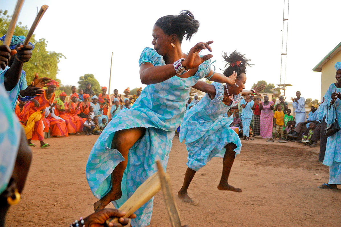
A dance festival in Dankunku, Central River, the Gambia. The tiny country’s rich music and dance traditions are the product of very diverse influences.
Photo credit Kevin Sharp
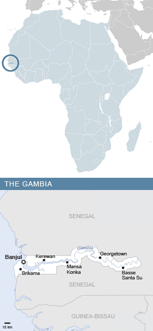
THE GAMBIA: OVERVIEW
Region: Western Africa
Population: 2.9 million | 0.2% of Africa’s population
Population density: 264.5 people per square kilometre | 5.1 x African average
Surface area: 11,300 square kilometres | 0.04% of Africa
Capital city: Banjul
THE GAMBIA: ECONOMY
World Bank classification: Low income
Currency: Dalasi (GMD)
Gross domestic product (GDP): $2.1 billion | 0.07% of Africa’s GDP
Average GDP per person: $696.40 | 0.3 x African average
Agriculture: 20.9% of economy
Industry: 17.2% of economy
Services and other: 61.9% of economy
Labour force unemployment rate: 9.6%
Share of women in the labour force: 55.8%
Share of men in the labour force: 74.8%
THE GAMBIA: INTERNATIONAL TRADE
Major export partners (share of exports): Mali 44.7% | China 29.1% | Senegal 10.9%
Major import partners (share of imports): Togo 25.5% | Côte d’Ivoire 12.4% | China 7.6%
Exports value: $106.0 million | 0.02% of Africa’s exports
Imports value: $484.4 million | 0.07% of Africa’s imports
THE GAMBIA: INDICATORS
Income inequality – Gini index: 53.6% (2021) | Africa rank: 28th out of 54 (higher score & rank = more inequality)
Human development index: Low | Score 0.524 | Africa rank: 33rd out of 54 | Global rank: 170th out of 193
Inequality-adjusted human development index: Score 0.329 | Africa rank: 35th out of 51 | Global rank: 151st out of 169
Gender inequality index: Score 0.578 | Africa rank: 35th out of 49 | Global rank: 154th out of 172 (higher score = less equality; higher rank = more equality)
LGBT equality index: 3% | Africa rank: 53rd out of 54 | Legal freedoms: 2% | Public opinion: 4%
Urbanisation: 63.9% of inhabitants live in cities
Government spending on education: 3.6% of GDP
Women in national parliament hold 10% of seats
Internet access: 30.0% of inhabitants use the internet
THE GAMBIA: ENVIRONMENT
Forests: 48% of land area
Annual carbon dioxide (CO2) emissions: 0.8 million tonnes | 0.06% of African total | 0.002% of world total
CO2 emissions per person: 0.3 tonnes | 0.3 x African average | 0.1 x world average
THE GAMBIA: HISTORY & HERITAGE
Official language: English
Other languages: Mandinka, Fula, Wolof, Serer, Jola
Colonised by: Britain 1821-1965
Independence: 1965 – from Britain
World Heritage Site: Kunta Kinteh Island and related sites present a testimony to the main periods and facets of the encounter between Africa and Europe along the River Gambia, a continuum stretching from pre-colonial and pre-slavery times to independence.
Ghana

Hair braiding at Makola Market in Accra, the capital of Ghana.
Photo credit Fiona Graham, WorldRemit, CC BY-SA 2.0.

GHANA: OVERVIEW
Region: Western Africa
Population: 34.1 million | 2.3% of Africa’s population
Population density: 142.0 people per square kilometre | 2.7 x African average
Surface area: 238,500 square kilometres | 0.8% of Africa
Capital city: Accra
GHANA: ECONOMY
World Bank classification: Lower middle income
Currency: cedi (GHS)
Gross domestic product (GDP): $74.3 billion | 2.6% of Africa’s GDP
Average GDP per person: $2,177.10 | 1.1 x African average
Agriculture: 18.6% of economy
Industry: 33.8% of economy
Services and other: 47.6% of economy
Labour force unemployment rate: 4.3%
Share of women in the labour force: 66.5%
Share of men in the labour force: 73.9%
GHANA: INTERNATIONAL TRADE
Major export partners (share of exports): Switzerland 18.2% | South Africa 11.7% | United Arab Emirates 10.2% | Major import partners (share of imports): China 18.7% | Netherlands 9.6% | India 6.4%
Exports value: $14.3 billion | 2.3% of Africa’s exports
Imports value: $13.9 billion | 2.1% of Africa’s imports
GHANA: INDICATORS
Income inequality – Gini index: 57.3% (2017) | Africa rank: 14th out of 54 (higher score & rank = more inequality)
Human development index: Medium | Score 0.628 | Africa rank: 17th out of 54 | Global rank: 143rd out of 193
Inequality-adjusted human development index: Score 0.399 | Africa rank: 18th out of 51 | Global rank: 132nd out of 169
Gender inequality index: Score 0.514 | Africa rank: 22nd out of 49 | Global rank: 138th out of 172 (higher score = less equality; higher rank = more equality)
LGBT equality index: 19% | Africa rank: 25th out of 54 | Legal freedoms: 20% | Public opinion: 18%
Urbanisation: 58.6% of inhabitants live in cities
Government spending on education: 4.4% of GDP
Women in national parliament hold 14% of seats
Internet access: 68.2% of inhabitants use the internet
GHANA: ENVIRONMENT
Forests: 41% of land area
Annual carbon dioxide (CO2) emissions: 13.1 million tonnes | 1.0% of African total | 0.04% of world total
CO2 emissions per person: 0.4 tonnes | 0.4 x African average | 0.1 x world average
GHANA: HISTORY & HERITAGE
Official language: English
Other languages: Asante Twi, Dagaare, Dagbani, Dangme, Ewe, Ga, Gonja, Kasem, Fante, Akuapem Twi, Nzema, Wasa, Talensi, Frafra, Hausa
Colonised by: Portugal 1482–1642 | Britain 1821-1957
Independence: 1957 – from Britain
World Heritage Site: The Asante Traditional Buildings, found to the north-east of Kumasi, are the last material remains of the great Asante civilization that reached its high point in the 18th century.
Guinea

Fisherwomen on the banks of the Niger River in the Kankan region of northeastern Guinea, on the Mali border.
Photo credit Julien Harnels

GUINEA: OVERVIEW
Region: Western Africa
Population: 14.2 million | 0.9% of Africa’s population
Population density: 58.2 people per square kilometre | 1.1 x African average
Surface area: 245,800 square kilometres | 0.8% of Africa
Capital city: Conakry
GUINEA: ECONOMY
World Bank classification: Lower middle income
Currency: Guinean franc (GNF)
Gross domestic product (GDP): $20.6 billion | 0.7% of Africa’s GDP
Average GDP per person: $1,450.40 | 0.7 x African average
Agriculture: 19.2% of economy
Industry: 38.5% of economy
Services and other: 42.3% of economy
Labour force unemployment rate: 4.6%
Share of women in the labour force: 63.9%
Share of men in the labour force: 78.6%
GUINEA: INTERNATIONAL TRADE
Major export partners (share of exports): China 48.7% | United Arab Emirates 23.2% | India 19.3%
Major import partners (share of imports): China 40.2% | India 8.5% | Netherlands 6.8%
Exports value: $7.9 billion | 1.3% of Africa’s exports
Imports value: $5.9 billion | 0.9% of Africa’s imports
GUINEA: INDICATORS
Income inequality – Gini index: 45.9% (2019) | Africa rank: 44th out of 54 (higher score & rank = more inequality)
Human development index: Low | Score 0.5 | Africa rank: 42nd out of 54 | Global rank: 179th out of 193
Inequality-adjusted human development index: Score 0.302 | Africa rank: 41st out of 51 | Global rank: 159th out of 169
Gender inequality index: Score 0.609 | Africa rank: 43rd out of 49 | Global rank: 163rd out of 172 (higher score = less equality; higher rank = more equality)
LGBT equality index: 15% | Africa rank: 28th out of 54 | Legal freedoms: 16% | Public opinion: 14%
Urbanisation: 39.1% of inhabitants live in cities
Government spending on education: 2.6% of GDP
Women in national parliament hold 30% of seats
Internet access: 39.9% of inhabitants use the internet
GUINEA: ENVIRONMENT
Forests: 27% of land area
Annual carbon dioxide (CO2) emissions: 3.4 million tonnes | 0.3% of African total | 0.01% of world total
CO2 emissions per person: 0.2 tonnes | 0.2 x African average | 0.05 x world average
GUINEA: HISTORY & HERITAGE
Official language: French
Other languages: Maninka, Fula, Susu
Colonised by: France 1898-1958
Independence: 1958 – from France
World Heritage Site: Mount Nimba, rising above the surrounding savannah, its slopes covered by dense forest at the foot of grassy mountain pastures, harbours rich flora and fauna that includes endemic species such as the viviparous toad.
Guinea-Bissau

A false-colour composite satellite image of the rivers, coast and islands of Guinea-Bissau. Infrared, red and blue light wavelengths bring out details of the complex patterns of the country’s shallow coastal waters, where silt carried by the Geba and other rivers washes out into the Atlantic Ocean.
Photo credit Nasa/USGS EROS Data Center, CC BY 2.0

GUINEA-BISSAU: OVERVIEW
Region: Western Africa
Population: 2.2 million | 0.15% of Africa’s population
Population density: 78.3 people per square kilometre | 1.5 x African average
Surface area: 36,125 square kilometres | 0.12% of Africa
Capital city: Bissau
GUINEA-BISSAU: ECONOMY
World Bank classification: Low income
Currency: CFA franc, Central Bank of West African States (XOF)
Gross domestic product (GDP): $1.6 billion | 0.05% of Africa’s GDP
Average GDP per person: $747.80 | 0.4 x African average
Agriculture: 32.3% of economy
Industry: 14% of economy
Services and other: 53.7% of economy
Labour force unemployment rate: 3.1%
Share of women in the labour force: 48.8%
Share of men in the labour force: 63.4%
GUINEA-BISSAU: INTERNATIONAL TRADE
Major export partners (share of exports): India 84.1% | Chile 4.5% | Côte d’Ivoire 2.8%
Major import partners (share of imports): Portugal 32.7% | Senegal 17.7% | China 14.9%
Exports value: $465 million | 0.08% of Africa’s exports
Imports value: $257 million | 0.04% of Africa’s imports
GUINEA-BISSAU: INDICATORS
Income inequality – Gini index: 49.3% (2022) | Africa rank: 40th out of 54 (higher score & rank = more inequality)
Human development index: Low | Score 0.514 | Africa rank: 37th out of 54 | Global rank: 174th out of 193
Inequality-adjusted human development index: Score 0.331 | Africa rank: 34th out of 51 | Global rank: 150th out of 169
Gender inequality index: Score 0.632 | Africa rank: 45th out of 49 | Global rank: 166th out of 172 (higher score = less equality; higher rank = more equality)
LGBT equality index: 32% | Africa rank: 14th out of 54 | Legal freedoms: 40% | Public opinion: 24%
Women in national parliament hold 9.8% of seats
Urbanisation: 43.8% of inhabitants live in cities
Government spending on education: 2.6% of GDP
Internet access: 31.6% of inhabitants use the internet
GUINEA-BISSAU: ENVIRONMENT
Forests: 70.1% of land area
Annual carbon dioxide (CO2) emissions: 300,000 tonnes | 0.02% of African total | 0.0009% of world total
CO2 emissions per person: 0.2 tonnes | 0.2 x African average | 0.05 x world average
GUINEA-BISSAU: HISTORY & HERITAGE
Official language: Portuguese
Other languages: Guinea-Bissau Creole (Kriol), Balanta, Fula, Mandjak, Mandinka, Papel, French
Colonised by: Portugal 1474-1973
Independence: 1973 – from Portugal
National heritage site: The Archipelago of Bijagos, consisting of 88 islands and islets, is the most biodiverse region of Guinea-Bissau.
Kenya

A panoramic view of Nairobi, Kenya’s capital and commercial centre. The city proper has a population of 3.1-million people, and its wider metropolitan area 6.5-million. Nairobi’s name comes from the Maasai “enkare nairobi”, or “cool water”, a reference to the Nairobi River which flows through the city.
Photo credit Babak Fakhamzadeh
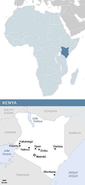
KENYA: OVERVIEW
Region: Eastern Africa
Population: 57.0 million | 3.8% of Africa’s population
Population density: 100.6 people per square kilometre | 1.9 x African average
Surface area: 580,400 square kilometres | 1.9% of Africa
Capital city: Nairobi
KENYA: ECONOMY
World Bank classification: Lower middle income
Currency: Kenyan shilling (KES)
Gross domestic product (GDP): $113.4 billion | 3.9% of Africa’s GDP
Average GDP per person: $1,989.20 | 1.0 x African average
Agriculture: 21.2% of economy
Industry: 17.3% of economy
Services and other: 61.5% of economy
Labour force unemployment rate: 5.7%
Share of women in the labour force: 67.7%
Share of men in the labour force: 75.8%
KENYA: INTERNATIONAL TRADE
Major export partners (share of exports): Uganda 11.1% | United States 9.2% | Netherlands 8%
Major import partners (share of imports): China 18.2% | United Arab Emirates 16.4% | India 10.1%
Exports value: $6.8 billion | 1.1% of Africa’s exports
Imports value: $19.2 billion | 2.9% of Africa’s imports
KENYA: INDICATORS
Income inequality – Gini index: 53.3% (2021) | Africa rank: 30th out of 54 (higher score & rank = more inequality)
Human development index: Medium | Score 0.628 | Africa rank: 17th out of 54 | Global rank: 143rd out of 193
Inequality-adjusted human development index: Score 0.456 | Africa rank: 12nd out of 51 | Global rank: 122nd out of 169
Gender inequality index: Score 0.526 | Africa rank: 27th out of 49 | Global rank: 143rd out of 172 (higher score = less equality; higher rank = more equality)
LGBT equality index: 21% | Africa rank: 24th out of 54 | Legal freedoms: 24% | Public opinion: 19%
Urbanisation: 30.4% of inhabitants live in cities
Government spending on education: 5.1% of GDP
Women in national parliament hold 23% of seats
Internet access: 29.0% of inhabitants use the internet
KENYA: ENVIRONMENT
Forests: 7% of land area
Annual carbon dioxide (CO2) emissions: 16.6 million tonnes | 1.2% of African total | 0.05% of world total
CO2 emissions per person: 0.3 tonnes | 0.3 x African average | 0.1 x world average
KENYA: HISTORY & HERITAGE
Official languages: English, Kiswahili
Colonised by: Britain 1888-1962
Independence: 1963 – from Britain
World Heritage Site: The Sacred Mijikenda Kaya Forests, 11 fortified villages set in forested land running over 200 kilometres along the coast. Known as kayas, the sites were first settled by the Mijikenda people in about 1560.
Lesotho

Dark clouds and sunshine in the Lesotho lowlands, close to the Fouriesburg border post into South Africa. These are just foothills in comparison to the rest of the mountainous country. Lesotho is the only country in the world which lies, in its entirety, over a kilometre above sea level. In fact, over 80% of its land is at an elevation of 1,800 metres or higher.
Photo credit Andrew Ashton

LESOTHO: OVERVIEW
Region: Southern Africa
Population: 2.3 million | 0.2% of Africa’s population
Population density: 77 people per square kilometre | 1.5 x African average
Surface area: 30,355 square kilometres | 0.1% of Africa
Capital city: Maseru
LESOTHO: ECONOMY
World Bank classification: Lower middle income
Currency: loti (LSL)
Gross domestic product (GDP): $2.3 billion | 0.08% of Africa’s GDP
Average GDP per person: $992.00 | 0.5 x African average
Agriculture: 7.1% of economy
Industry: 34.7% of economy
Services and other: 58.2% of economy
Labour force unemployment rate: 16.1%
Share of women in the labour force: 57.4%
Share of men in the labour force: 72.8%
LESOTHO: INTERNATIONAL TRADE
Major export partners (share of exports): South Africa 50.4% | United States 26.2% | Belgium 19.1%
Major import partners (share of imports): South Africa 77.4% | China 6.2% | Taiwan 4.2%
Exports value: $825 million | 0.1% of Africa’s exports
Imports value: $1.8 billion | 0.3% of Africa’s imports
LESOTHO: INDICATORS
Income inequality – Gini index: 58.4% (2018) | Africa rank: 11th out of 54 (higher score & rank = more inequality)
Human development index: Medium | Score 0.55 | Africa rank: 31st out of 54 | Global rank: 167th out of 193
Inequality-adjusted human development index: Score 0.357 | Africa rank: 28th out of 51 | Global rank: 143rd out of 169
Gender inequality index: Score 0.534 | Africa rank: 28th out of 49 | Global rank: 144th out of 172 (higher score = less equality; higher rank = more equality)
LGBT equality index: 43% | Africa rank: 9th out of 54 | Legal freedoms: 53% | Public opinion: 32%
Urbanisation: 28.6% of inhabitants live in cities
Government spending on education: 6.1% of GDP
Women in national parliament hold 25% of seats
Internet access: 47% of inhabitants use the internet
LESOTHO: ENVIRONMENT
Forests: 1.1% of land area
Annual carbon dioxide (CO2) emissions: 3.2 million tonnes | 0.2% of African total | 0.01% of world total
CO2 emissions per person: 1.4 tonnes | 1.6 x African average | 0.3 x world average
LESOTHO: HISTORY & HERITAGE
Official languages: English, Sesotho
Colonised by: Britain 1868-1966
Independence: 1966 – from Britain
World Heritage Site: The Maloti Drakensberg Transboundary World Heritage Site is known for its rock art and mountain landscape.
Liberia

The coastal city of Monrovia, Liberia’s capital and largest city. Monrovia is named after American president James Monroe (1758 – 1831), a prominent supporter of the colonisation of Liberia by the resettlement of freed slaves.
Photo credit JB Dodane

LIBERIA: OVERVIEW
Region: Western Africa
Population: 5.6 million | 0.4% of Africa’s population
Population density: 58.3 people per square kilometre | 1.1 x African average
Surface area: 111,369 square kilometres | 0.4% of Africa
Capital city: Monrovia
LIBERIA: ECONOMY
World Bank classification: Low income
Currency: Liberian dollar (LRD)
Gross domestic product (GDP): $3.3 billion | 0.1% of Africa’s GDP
Average GDP per person: $615.80 | 0.3 x African average
Agriculture: 74% of economy
Industry: 8.6% of economy
Services and other: 17.5% of economy
Labour force unemployment rate: 2.8%
Share of women in the labour force: 72.6%
Share of men in the labour force: 81.5%
LIBERIA: INTERNATIONAL TRADE
Major export partners (share of exports): Switzerland 31% | United Kingdom 13.2% | France 8.6%
Major import partners (share of imports): China 38.5% | Singapore 20% | South Korea 15.1%
Exports value: $717 million | 0.1% of Africa’s exports
Imports value: $2.6 billion | 0.4% of Africa’s imports
LIBERIA: INDICATORS
Income inequality – Gini index: 50.8% (2016) | Africa rank: 37th out of 54 (higher score & rank = more inequality)
Human development index: Low | Score 0.51 | Africa rank: 40th out of 54 | Global rank: 177th out of 193
Inequality-adjusted human development index: Score 0.326 | Africa rank: 37th out of 51 | Global rank: 153rd out of 169
Gender inequality index: Score 0.646 | Africa rank: 46th out of 49 | Global rank: 167th out of 172 (higher score = less equality; higher rank = more equality)
LGBT equality index: 16% | Africa rank: 27th out of 54 | Legal freedoms: 24% | Public opinion: 9%
Urbanisation: 51.6% of inhabitants live in cities
Government spending on education: 2.6% of GDP
Women in national parliament hold 11% of seats
Internet access: 30.1% of inhabitants use the internet
LIBERIA: ENVIRONMENT
Forests: 78.8% of land area
Annual carbon dioxide (CO2) emissions: 0.6 million tonnes | 0.05% of African total | 0.002% of world total
CO2 emissions per person: 0.1 tonnes | 0.1 x African average | 0.02 x world average
LIBERIA: HISTORY & HERITAGE
Official language: English
National heritage site: Providence Island is a former trade post and was the first point of arrival for freed American Slaves. The guitar-shaped island has a cement pillar and concrete floor believed to be the first concrete work in the history of the country, as well as an ancient water well and an old docking platform for incoming canoes and ships. On the site is also a 250-year-old cotton tree, the oldest in Liberia.
Libya

In the ancient desert oasis town of Ghadames in northwestern Libya, buildings are designed with thick walls of mud, lime, and palm tree trunks to withstand the Sahara’s extremes of heat and cold. Covered alleyways between dwellings help cut the summer heat.
Photo credit Luca Galuzzi

LIBYA: OVERVIEW
Region: Northern Africa
Population: 7.4 million | 0.5% of Africa’s population
Population density: 4.4 people per square kilometre | 0.09 x African average
Surface area: 1,676,198 square kilometres | 5.7% of Africa
Capital city: Tripoli
LIBYA: ECONOMY
World Bank classification: Upper middle income
Currency: Libyan dinar (LYD)
Gross domestic product (GDP): $40.5 billion | 1.4% of Africa’s GDP
Average GDP per person: $5,950.50 | 3 x African average
Agriculture: 3.7% of economy
Industry: 43.8% of economy
Services and other: 52.5% of economy
Labour force unemployment rate: 18.1%
Share of women in the labour force: 35%
Share of men in the labour force: 61.6%
LIBYA: INTERNATIONAL TRADE
Major export partners (share of exports): Italy 22.1% | Germany 14.3% | Spain 8.6%
Major import partners (share of imports): China 17.6% | Türkiye 14.7% | Italy 8.3%
Exports value: $25.1 billion | 4.3% of Africa’s exports
Imports value: $11.9 billion | 1.7% of Africa’s imports
LIBYA: INDICATORS
Income inequality – Gini index: 30.9% (2008) | Africa rank: 53rd out of 54 (higher score & rank = more inequality)
Human development index: High | Score 0.721 | Africa rank: 9th out of 54 | Global rank: 115th out of 193
Gender inequality index: Score 0.253 | Africa rank: 2nd out of 49 | Global rank: 65th out of 172 (higher score = less equality; higher rank = more equality)
LGBT equality index: 13% | Africa rank: 35th out of 54 | Legal freedoms: 8% | Public opinion: 19%
Urbanisation: 80.4% of inhabitants live in cities
:% of GDP
Women in national parliament hold 16.5% of seats
Internet access: 88.4% of inhabitants use the internet
LIBYA: ENVIRONMENT
Forests: 0.1% of land area
Annual carbon dioxide (CO2) emissions: 43.5 million tonnes | 3.3% of African total | 0.1% of world total
CO2 emissions per person: 6.5 tonnes | 7.2 x African average | 1.5 x world average
LIBYA: HISTORY & HERITAGE
Official languages: Arabic
Other languages: Libyan Arabic, Tamazight, Italian
Colonised by: Italy 1911-1943
Independence: 1947 – from Italy
World Heritage Site: Cyrene was one of the principal cities in the ancient Hellenic world.
Madagascar

The Avenue of the Baobabs near Morondava in western Madagascar. There are nine species of baobab tree in the world, and six of them are only found in Madagascar. Of the rest, two are on the mainland of Africa, and one in Australia. (Frank Vassen, CC BY 2.0)

MADAGASCAR: OVERVIEW
Region: Eastern Africa
Population: 32 million | 2.1% of Africa’s population
Population density: 54.9 people per square kilometre | 1.1 x African average
Surface area: 587,041 square kilometres | 2% of Africa
Capital city: Antananarivo
MADAGASCAR: ECONOMY
World Bank classification: Low income
Currency: ariary (MGA)
Gross domestic product (GDP): $15 billion | 0.4% of Africa’s GDP
Average GDP per person: $505.00 | 0.3 x African average
Agriculture: 23.5% of economy
Industry: 23.6% of economy
Services and other: 50.4% of economy
Labour force unemployment rate: 1.8%
Share of women in the labour force: 82.6%
Share of men in the labour force: 87.8%
MADAGASCAR: INTERNATIONAL TRADE
Major export partners (share of exports): France 14.5% | United States 12.6% | Japan 8.2%
Major import partners (share of imports): China 17% | Oman 13.5% | France 11.2%
Exports value: $3.3 billion | 0.6% of Africa’s exports
Imports value: $4.8 billion | 0.7% of Africa’s imports
MADAGASCAR: INDICATORS
Income inequality – Gini index: 56.7% (2013) | Africa rank: 18th out of 54 (higher score & rank = more inequality)
Human development index: Low | Score 0.487 | Africa rank: 45th out of 54 | Global rank: 183rd out of 193
Inequality-adjusted human development index: Score 0.319 | Africa rank: 39th out of 51 | Global rank: 157th out of 169
Gender inequality index: Score 0.584 | Africa rank: 37th out of 49 | Global rank: 157th out of 172 (higher score = less equality; higher rank = more equality)
LGBT equality index: 32% | Africa rank: 14th out of 54 | Legal freedoms: 41% | Public opinion: 22%
Urbanisation: 37.9% of inhabitants live in cities
Government spending on education: 3.2% of GDP
Women in national parliament hold 18.5% of seats
Internet access: 20.6% of inhabitants use the internet
MADAGASCAR: ENVIRONMENT
Forests: 21.3% of land area
Annual carbon dioxide (CO2) emissions: 4.4 million tonnes | 0.3% of African total | 0.01% of world total
CO2 emissions per person: 0.2 tonnes | 0.2 x African average | 0.05 x world average
MADAGASCAR: HISTORY & HERITAGE
Official languages: Malagasy, French
Colonised by: France 1896-1958
Independence: 1960 – from France
World Heritage Site: The Royal Hill of Ambohimanga, the cradle of a 500-year-old kingdom and dynasty that retains enormous spiritual importance to this day.
Malawi

A sense of the size of Lake Malawi, in a view from the road to the town of Livingstonia in the north of the country. Lake Malawi also borders Tanzania, where it is known as Lake Nyasa, and Mozambique, where it is known as Lago Niassa. It is the ninth largest lake in the world and home to more species of fish than any other. Some 90% of these species are endemic, only found in Lake Malawi.
Photo credit Jack Zalium

MALAWI: OVERVIEW
Region: Eastern Africa
Population: 21.7 million | 1.4% of Africa’s population
Population density: 229 people per square kilometre | 4.5 x African average
Surface area: 117,726 square kilometres | 0.4% of Africa
Capital city: Lilongwe
MALAWI: ECONOMY
World Bank classification: Low income
Currency: kwacha (MWK)
Gross domestic product (GDP): $12.6 billion | 0.4% of Africa’s GDP
Average GDP per person: $615.50 | 0.3 x African average
Agriculture: 29.4% of economy
Industry: 18% of economy
Services and other: 52.5% of economy
Labour force unemployment rate: 5%
Share of women in the labour force: 63.7%
Share of men in the labour force: 75.4%
MALAWI: INTERNATIONAL TRADE
Major export partners (share of exports): Belgium 15.9% | Tanzania 10.8% | China 5.6%
Major import partners (share of imports): China 17.4% | South Africa 15.6% | United Arab Emirates 14.1%
Exports value: $966 million | 0.2% of Africa’s exports
Imports value: $3.1 billion | 0.5% of Africa’s imports
MALAWI: INDICATORS
Income inequality – Gini index: 53.5% (2020) | Africa rank: 29th out of 54 (higher score & rank = more inequality)
Human development index: Low | Score 0.517 | Africa rank: 35th out of 54 | Global rank: 172nd out of 193
Inequality-adjusted human development index: Score 0.365 | Africa rank: 23rd out of 51 | Global rank: 137th out of 169
Gender inequality index: Score 0.581 | Africa rank: 36th out of 49 | Global rank: 155th out of 172 (higher score = less equality; higher rank = more equality)
LGBT equality index: 8% | Africa rank: 46th out of 54 | Legal freedoms: 10% | Public opinion: 5%
Urbanisation: 17.2% of inhabitants live in cities
Government spending on education: 3.3% of GDP
Women in national parliament hold 20.7% of seats
Internet access: 27.7% of inhabitants use the internet
MALAWI: ENVIRONMENT
Forests: 23.3% of land area
Annual carbon dioxide (CO2) emissions: 1.6 million tonnes | 0.1% of African total | 0.004% of world total
CO2 emissions per person: 0.1 tonnes | 0.1 x African average | 0.02 x world average
MALAWI: HISTORY & HERITAGE
Official language: English
Other languages: Chichewa
Colonised by: Britain 1891-1964
Independence: 1964 – from Britain
World Heritage Site: The Chongoni Rock Art Area, lying in a cluster of forested granite hills high on the plateau of central Malawi, holds the richest concentration of rock art in Central Africa.
Mali
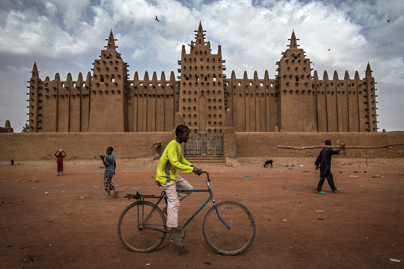
The Grand Mosque of Djenné in the Niger Delta region of central Mali is the largest adobe – mud-built – structure in the world. The first mosque on the site is thought to have been built in the 1200s. The current structure is a century old, built in 1907. After the rainy season the mosque’s surface has been washed thin, so the local community gathers to replaster it. The protruding wooden struts are not structural: they provide footholds so people can reach every part of the building to reseal its surface with mud.
Photo credit Marco Dormino, UN Photo

MALI: OVERVIEW
Region: Western Africa
Population: 24.5 million | 1.6% of Africa’s population
Population density: 20.1 people per square kilometre | 0.4 x African average
Surface area: 1,240,192 square kilometres | 4.2% of Africa
Capital city: Bamako
MALI: ECONOMY
World Bank classification: Low income
Currency: CFA franc (XOF)
Gross domestic product (GDP): $18.8 billion | 0.7% of Africa’s GDP
Average GDP per person: $833.30 | 0.4 x African average
Agriculture: 38.6% of economy
Industry: 21.9% of economy
Services and other: 39.4% of economy
Labour force unemployment rate: 3.2%
Share of women in the labour force: 52%
Share of men in the labour force: 82.2%
MALI: INTERNATIONAL TRADE
Major export partners (share of exports): United Arab Emirates 79.2% | Switzerland 12.4% | Australia 4.1%
Major import partners (share of imports): Senegal 17% | China 14.3% | Côte d’Ivoire 14.1%
Exports value: $4.5 billion | 0.8% of Africa’s exports
Imports value: $8.7 billion | 1.3% of Africa’s imports
MALI: INDICATORS
Income inequality – Gini index: 39.1% (2021) | Africa rank: 49th out of 54 (higher score & rank = more inequality)
Human development index: Low | Score 0.419 | Africa rank: 49th out of 54 | Global rank: 188th out of 193
Inequality-adjusted human development index: Score 0.281 | Africa rank: 44th out of 51 | Global rank: 162nd out of 169
Gender inequality index: Score 0.612 | Africa rank: 44th out of 49 | Global rank: 164th out of 172 (higher score = less equality; higher rank = more equality)
LGBT equality index: 8% | Africa rank: 46th out of 54 | Legal freedoms: 6% | Public opinion: 9%
Urbanisation: 43.1% of inhabitants live in cities
Government spending on education: 4.4% of GDP
Women in national parliament hold 28.6% of seats
Internet access: 33.1% of inhabitants use the internet
MALI: ENVIRONMENT
Forests: 10.9% of land area
Annual carbon dioxide (CO2) emissions: 6.3 million tonnes | 0.5% of African total | 0.02% of world total
CO2 emissions per person: 0.3 tonnes | 0.3 x African average | 0.07 x world average
MALI: HISTORY & HERITAGE
Official language: French
Other languages: Bambara, Bomu, Tieyaxo Bozo, Toro So Dogon, Maasina Fulfulde, Hassaniya Arabic, Mamara Senoufo, Kita Maninkakan, Soninke, Koyraboro Senni, Syenara Senoufo, Tamasheq, Xaasongaxango
Colonised by: France 1892-1960
Independence: 1960 – from France
World Heritage Site: The city of Timbuktu was an intellectual and spiritual capital and the centre of Islamic thought in Africa from the 15th to the 16th centuries.
Mauritania

Men playing the traditional Mauritanian board game of Kharbaga – similar to zamma and draughts – in Ouadane (or Wādān), a small town in the desert region of central Mauritania.
Photo credit Evgeni Zotov

MAURITANIA: OVERVIEW
Region: Western Africa
Population: 5.2 million | 0.3% of Africa’s population
Population density: 5 people per square kilometre | 0.1 x African average
Surface area: 1,030,700 square kilometres | 3.5% of Africa
Capital city: Nouakchott
MAURITANIA: ECONOMY
World Bank classification: Lower middle income
Currency: ouguiya (MRU)
Gross domestic product (GDP): $11 billion | 0.4% of Africa’s GDP
Average GDP per person: $2,322 | 1.2 x African average
Agriculture: 20.3% of economy
Industry: 33.% of economy
Services and other: 4.1% of economy
Labour force unemployment rate: 10.%
Share of women in the labour force: 26.4%
Share of men in the labour force: 57.2%
MAURITANIA: INTERNATIONAL TRADE
Major export partners (share of exports): China 23.3% | Canada 18.4% | Spain 11.2%
Major import partners (share of imports): United Arab Emirates 18.3% | Spain 16.1% | Japan 6.8%
Exports value: $3.3 billion | 0.6% of Africa’s exports
Imports value: $5.3 billion | 0.8% of Africa’s imports
MAURITANIA: INDICATORS
Income inequality – Gini index: 47.9% (2020) | Africa rank: 43rd out of 54 (higher score & rank = more inequality)
Human development index: Medium | Score 0.563 | Africa rank: 28th out of 54 | Global rank: 163rd out of 193
Inequality-adjusted human development index: Score 0.374 | Africa rank: 22nd out of 51 | Global rank: 136th out of 169
Gender inequality index: Score 0.603 | Africa rank: 41st out of 49 | Global rank: 161st out of 172 (higher score = less equality; higher rank = more equality)
LGBT equality index: 10% | Africa rank: 40th out of 54 | Legal freedoms: 4% | Public opinion: 16%
Urbanisation: 54.5% of inhabitants live in cities
Government spending on education: 1.7% of GDP
Women in national parliament hold 23.3% of seats
Internet access: 44.4% of inhabitants use the internet
MAURITANIA: ENVIRONMENT
Forests: 0.3% of land area
Annual carbon dioxide (CO2) emissions: 4.6 million tonnes | 0.4% of African total | 0.01% of world total
CO2 emissions per person: 1 tonne | 1.1 x African average | 0.2 x world average
MAURITANIA: HISTORY & HERITAGE
Official language: Arabic
Other languages: Hassaniya Arabic, Pulaar, Soninke, Wolof, Zenaga Berber, French
Colonised by: France 1903-1960
Independence: 1960 – from France
World Heritage Site: The Ancient Ksour of Ouadane, Chinguetti, Tichitt and Oualata were trading and religious centres founded in the 11th and 12th centuries to serve caravans crossing the Sahara.
Mauritius

Le Morne Brabant Peninsula in Mauritius. The island’s natural beauty has allowed it to develop a successful tourism industry, which contributes some 8.4% to the country’s GDP.
Photo credit Sofitel So Mauritius

MAURITIUS: OVERVIEW
Region: Eastern Africa
Population: 1.3 million | 0.08% of Africa’s population
Population density: 626.2 people per square kilometre | 12.2 x African average
Surface area: 1,979 square kilometres | 0.007% of Africa
Capital city: Port Louis
MAURITIUS: ECONOMY
World Bank classification: Upper middle income
Currency: Mauritian rupee (MUR)
Gross domestic product (GDP): $12.9 billion | 0.4% of Africa’s GDP
Average GDP per person: $9,92.80 | 4.9 x African average
Agriculture: 3.9% of economy
Industry: 21% of economy
Services and other: 75.1% of economy
Labour force unemployment rate: 4.2%
Share of women in the labour force: 43%
Share of men in the labour force: 68%
MAURITIUS: INTERNATIONAL TRADE
Major export partners (share of exports): France 14.7% | South Africa 10.8% | United States 9.4%
Major import partners (share of imports): China 15.8% | United Arab Emirates 11.1% | India 10.2%
Exports value: $1.9 billion | 0.3% of Africa’s exports
Imports value: $6.3 billion | 0.9% of Africa’s imports
MAURITIUS: INDICATORS
Income inequality – Gini index: 49.2% (2017) | Africa rank: 41st out of 54 (higher score & rank = more inequality)
Human development index: Very High | Score 0.806 | Africa rank: 2nd out of 54 | Global rank: 73rd out of 193
Inequality-adjusted human development index: Score 0.669 | Africa rank: 2nd out of 51 | Global rank: 69th out of 169
Gender inequality index: Score 0.352 | Africa rank: 4th out of 49 | Global rank: 87th out of 172 (higher score = less equality; higher rank = more equality)
LGBT equality index: 53% | Africa rank: 4th out of 54 | Legal freedoms: 55% | Public opinion: 52%
Urbanisation: 40.8% of inhabitants live in cities
Government spending on education: 4.7% of GDP
Women in national parliament hold 20% of seats
Internet access: 75.5% of inhabitants use the internet
MAURITIUS: ENVIRONMENT
Forests: 19.4% of land area
Annual carbon dioxide (CO2) emissions: 4.1 million tonnes | 0.3% of African total | 0.01% of world total
CO2 emissions per person: 3.1 tonnes | 3.4 x African average | 0.7 x world average
MAURITIUS: HISTORY & HERITAGE
Languages: Mauritian Creole, French, English, Bhojpuri
Colonised by: Netherlands 1638-1710 | France 1715-1810 | Britain 1810-1968
Independence: 1968 – from Britain
World Heritage Site: Aapravasi Ghat, a fortlike stone complex established by the UK in 1834, a year after slavery was abolished, as a global transit point for a new kind of slavery: indentured labour. About half a million mainly Indian labourers were processed through the site from 1849 to 1923.
Morocco

Street life in Essaouira, an ancient city in western Morocco on the Atlantic coast.
Photo credit Andrea Moroni

MOROCCO: OVERVIEW
Region: Northern Africa
Population: 38.1 million | 2.5% of Africa’s population
Population density: 85.3 people per square kilometre | 1.7 x African average
Surface area: 446,550 square kilometres | 1.5% of Africa
Capital city: Rabat
MOROCCO: ECONOMY
World Bank classification: Lower middle income
Currency: Moroccan dirham (MAD)
Gross domestic product (GDP): $130.9 billion | 4.6% of Africa’s GDP
Average GDP per person: $3,494.90 | 1.7 x African average
Agriculture: 11.4% of economy
Industry: 28.2% of economy
Services and other: 60.3% of economy
Labour force unemployment rate: 9.7%
Share of women in the labour force: 20%
Share of men in the labour force: 67.9%
MOROCCO: INTERNATIONAL TRADE
Major export partners (share of exports): Spain 19.6% | France 19.1% | India 6.4%
Major import partners (share of imports): Spain 14.1% | France 10.6% | China 10%
Exports value: $44 billion | 7.6% of Africa’s exports
Imports value: $71.5 billion | 10.4% of Africa’s imports
MOROCCO: INDICATORS
Income inequality – Gini index: 43.4% (2014) | Africa rank: 47th out of 54 (higher score & rank = more inequality)
Human development index: High | Score 0.71 | Africa rank: 10th out of 54 | Global rank: 120th out of 193
Inequality-adjusted human development index: Score 0.517 | Africa rank: 7th out of 51 | Global rank: 109th out of 169
Gender inequality index: Score 0.438 | Africa rank: 8th out of 49 | Global rank: 113rd out of 172 (higher score = less equality; higher rank = more equality)
LGBT equality index: 13% | Africa rank: 35th out of 54 | Legal freedoms: 12% | Public opinion: 15%
Urbanisation: 63% of inhabitants live in cities
Women in national parliament hold 24.3% of seats
Internet access: 90.7% of inhabitants use the internet
MOROCCO: ENVIRONMENT
Forests: 12.9% of land area
Annual carbon dioxide (CO2) emissions: 67.1 million tonnes | 5.2% of African total | 0.2% of world total
CO2 emissions per person: 1.8 tonnes | 2 x African average | 0.4 x world average
MOROCCO: HISTORY & HERITAGE
Official languages: Arabic, Berber
Colonised by: Spain 1912-1956 | France 1912-1956
Independence: 1956 – from Spain and France
World Heritage Site: The Medina of Marrakesh, a massive old Islamic capital from the 11th century enclosed by 16 kilometres of ramparts and gates.
Mozambique

The Chapel of Nossa Senhora de Baluarte (Our Lady of the Bulwark) lies next to Fort São Sebastião on the easternmost tip of the Island of Mozambique (Ilha de Moçambique), off the coast of northern Mozambique. Portuguese colonial forces established a port and naval base on the island in 1507. The chapel, built in 1522, is thought to be the oldest European building in the southern hemisphere.
Photo credit Raul Soler, CC BY-NC 2.0

MOZAMBIQUE: OVERVIEW
Region: Eastern Africa
Population: 34.6 million | 2.3% of Africa’s population
Population density: 44 people per square kilometre | 0.9 x African average
Surface area: 799,380 square kilometres | 2.7% of Africa
Capital city: Maputo
MOZAMBIQUE: ECONOMY
World Bank classification: Low income
Currency: Mozambican metical (MZN)
Gross domestic product (GDP): $18.4 billion | 0.6% of Africa’s GDP
Average GDP per person: $558.30 | 0.3 x African average
Agriculture: 29.7% of economy
Industry: 25.3% of economy
Services and other: 45% of economy
Labour force unemployment rate: 3.7%
Share of women in the labour force: 78.3%
Share of men in the labour force: 79.6%
MOZAMBIQUE: INTERNATIONAL TRADE
Major export partners (share of exports): India 15.6% | South Africa 14.2% | United Kingdom 14%
Major import partners (share of imports): South Korea 23.2% | South Africa 15.4% | United Arab Emirates 10.3%
Exports value: $8.3 billion | 1.4% of Africa’s exports
Imports value: $10.1 billion | 1.5% of Africa’s imports
MOZAMBIQUE: INDICATORS
Income inequality – Gini index: 63% (2020) | Africa rank: 5th out of 54 (higher score & rank = more inequality)
Human development index: Low | Score 0.493 | Africa rank: 44th out of 54 | Global rank: 182nd out of 193
Inequality-adjusted human development index: Score 0.297 | Africa rank: 42nd out of 51 | Global rank: 160th out of 169
Gender inequality index: Score 0.479 | Africa rank: 11th out of 49 | Global rank: 120th out of 172 (higher score = less equality; higher rank = more equality)
LGBT equality index: 51% | Africa rank: 6th out of 54 | Legal freedoms: 55% | Public opinion: 47%
Urbanisation: 36.5% of inhabitants live in cities
Government spending on education: 6.9% of GDP
Women in national parliament hold 43.2% of seats
Internet access: 21.2% of inhabitants use the internet
MOZAMBIQUE: ENVIRONMENT
Forests: 46.4% of land area
Annual carbon dioxide (CO2) emissions: 6.9 million tonnes | 0.5% of African total | 0.02% of world total
CO2 emissions per person: 0.2 tonnes | 0.2 x African average | 0.05 x world average
MOZAMBIQUE: HISTORY & HERITAGE
Official language: Portuguese
Other languages: Emakhuwa, Cisena, Xichangana, Elomwe, Cishona, Xitswa, Xironga, Chichewa, Cinyungwe, Cicopi, Ciyao, Shimakonde
Colonised by: Portugal 1498-1975
Independence: 1975 – from Portugal
World Heritage Site: The Island of Mozambique and its fortified city was a former Portuguese trading post on the route to India, used since the 16th century.
Namibia

The pretty harbour town of Lüderitz on the forbidding west coast of Namibia, on the Atlantic seaboard, was one of the country’s earliest colonial settlements. Today it is a niche tourist destination.
Photo credit Damien du Toit

NAMIBIA: OVERVIEW
Region: Southern Africa
Population: 3 million | 0.2% of Africa’s population
Population density: 3.7 people per square kilometre | 0.07 x African average
Surface area: 825,229 square kilometres | 2.8% of Africa
Capital city: Windhoek
NAMIBIA: ECONOMY
World Bank classification: Lower middle income
Currency: Namibia dollar (NAD)
Gross domestic product (GDP): $12.6 billion | 0.4% of Africa’s GDP
Average GDP per person: $4,911.30 | 2.4 x African average
Agriculture: 9.3% of economy
Industry: 30.4% of economy
Services and other: 60.3% of economy
Labour force unemployment rate: 19.4%
Share of women in the labour force: 56%
Share of men in the labour force: 63.7%
NAMIBIA: INTERNATIONAL TRADE
Major export partners (share of exports): Botswana 19.3% | South Africa 18.6% | China 12.5%
Major import partners (share of imports): South Africa 35.7% | China 8.9% | India 6.7%
Exports value: $5.5 billion | 0.9% of Africa’s exports
Imports value: $7.2 billion | 1.1% of Africa’s imports
NAMIBIA: INDICATORS
Income inequality – Gini index: 61.6% (2016) | Africa rank: 8th out of 54 (higher score & rank = more inequality)
Human development index: Medium | Score 0.665 | Africa rank: 14th out of 54 | Global rank: 136th out of 193
Inequality-adjusted human development index: Score 0.438 | Africa rank: 13rd out of 51 | Global rank: 125th out of 169
Gender inequality index: Score 0.448 | Africa rank: 10th out of 49 | Global rank: 116th out of 172 (higher score = less equality; higher rank = more equality)
LGBT equality index: 44% | Africa rank: 8th out of 54 | Legal freedoms: 54% | Public opinion: 33%
Urbanisation: 51% of inhabitants live in cities
Government spending on education: 9.5% of GDP
Women in national parliament hold 44.2% of seats
Internet access: 62.2% of inhabitants use the internet
NAMIBIA: ENVIRONMENT
Forests: 8% of land area
Annual carbon dioxide (CO2) emissions: 3.5 million tonnes | 0.3% of African total | 0.01% of world total
CO2 emissions per person: 1.4 tonnes | 1.6 x African average | 0.33 x world average
NAMIBIA: HISTORY & HERITAGE
Official language: English
Other languages: Afrikaans, German, Ju’hoansi, Khoekhoegowab, Oshiwambo, Otjiherero, Rukwangali, Rumanyo, Setswana, Silozi, Thimbukushu
Colonised by: Germany 1884-1915 | South Africa 1915-1990
Independence: 1990 – from South Africa
World Heritage Site: The Namib Sand Sea, covering an area of over 3-million hectares, is the only coastal desert in the world that includes extensive dune fields influenced by fog.
Niger

A classroom at Carrefour Jeunesse Niger, a vocational dressmaking school in Niamey. The school designed by architect Odile Vandermeeren and constructed by local artisans using traditional adobe building techniques, with the murals painted by local female artists. The project was a finalist in the international Terra Award for earthen architecture.
Photo credit Gustave Deghilage

NIGER: OVERVIEW
Region: Western Africa
Population: 27 million | 1.8% of Africa’s population
Population density: 21.3 people per square kilometre | 0.4 x African average
Surface area: 1,267,000 square kilometres | 4.3% of Africa
Capital city: Niamey
NIGER: ECONOMY
World Bank classification: Low income
Currency: CFA franc, Central Bank of West African States (XOF)
Gross domestic product (GDP): $15.4 billion | 0.5% of Africa’s GDP
Average GDP per person: $588.20 | 0.3 x African average
Agriculture: 39.5% of economy
Industry: 21.8% of economy
Services and other: 38.8% of economy
Labour force unemployment rate: 0.5%
Share of women in the labour force: 62.3%
Share of men in the labour force: 84.4%
NIGER: INTERNATIONAL TRADE
Major export partners (share of exports): France 33.2% | Mali 18.7% | Nigeria 16%
Major import partners (share of imports): China 23.9% | France 21% | India 10.3%
Exports value: $519 million | 0.09% of Africa’s exports
Imports value: $2.5 billion | 0.4% of Africa’s imports
NIGER: INDICATORS
Income inequality – Gini index: 48.8% (2022) | Africa rank: 42nd out of 54 (higher score & rank = more inequality)
Human development index: Low | Score 0.419 | Africa rank: 49th out of 54 | Global rank: 188th out of 193
Inequality-adjusted human development index: Score 0.265 | Africa rank: 47th out of 51 | Global rank: 165th out of 169
Gender inequality index: Score 0.591 | Africa rank: 40th out of 49 | Global rank: 160th out of 172 (higher score = less equality; higher rank = more equality)
LGBT equality index: 26% | Africa rank: 20th out of 54 | Legal freedoms: 40% | Public opinion: 12%
Urbanisation: 16.5% of inhabitants live in cities
Government spending on education: 3.5% of GDP
Women in national parliament hold 30.7% of seats
Internet access: 16.9% of inhabitants use the internet
NIGER: ENVIRONMENT
Forests: 0.8% of land area
Annual carbon dioxide (CO2) emissions: 2.6 million tonnes | 0.2% of African total | 0.008% of world total
CO2 emissions per person: 0.1 tonnes | 0.1 x African average | 0.02 x world average
NIGER: HISTORY & HERITAGE
Official language: French
Other languages: Arabic, Buduma, Fulfulde, Gourmanchéma, Hausa, Kanuri, Zarma & Songhai, Tamasheq, Tassawaq, Tebu
Colonised by: France 1900-1960
Independence: 1960 – from France
World Heritage Site: Agadez, known as the gateway to the Sahara desert, developed in the 15th and 16th centuries when the Sultanate of Aïr was established and Touareg groups settled in the city in the boundaries of nomadic encampments, creating street patterns still in place today.
Nigeria

The National Mosque of Nigeria in Abuja, the country’s capital. The building was constructed in 1984.
Photo credit Jeff Attaway

NIGERIA: OVERVIEW
Region: Western Africa
Population: 232.7 million | 15.4% of Africa’s population
Population density: 255.5 people per square kilometre | 5 x African average
Surface area: 923,768 square kilometres | 3.1% of Africa
Capital city: Abuja
NIGERIA: ECONOMY
World Bank classification: Lower middle income
Currency: naira (NGN)
Gross domestic product (GDP): $475.1 billion | 16.5% of Africa’s GDP
Average GDP per person: $2,173.80 | 1.1 x African average
Agriculture: 24.1% of economy
Industry: 31.2% of economy
Services and other: 44.7% of economy
Labour force unemployment rate: 3.5%
Share of women in the labour force: 52.3%
Share of men in the labour force: 65.9%
NIGERIA: INTERNATIONAL TRADE
Major export partners (share of exports): Netherlands 12.6% | Spain 9.4% | India 8.4%
Major import partners (share of imports): China 18.4% | Singapore 14.3% | Belgium 9.4%
Exports value: $65.1 billion | 11.2% of Africa’s exports
Imports value: $65 billion | 9.5% of Africa’s imports
NIGERIA: INDICATORS
Income inequality – Gini index: 36.2% (2019) | Africa rank: 50th out of 54 (higher score & rank = more inequality)
Human development index: Medium | Score 0.56 | Africa rank: 29th out of 54 | Global rank: 164th out of 193
Inequality-adjusted human development index: Score 0.379 | Africa rank: 21st out of 51 | Global rank: 135th out of 169
Gender inequality index: Score 0.677 | Africa rank: 49th out of 49 | Global rank: 171st out of 172 (higher score = less equality; higher rank = more equality)
LGBT equality index: 15% | Africa rank: 28th out of 54 | Legal freedoms: 15% | Public opinion: 15%
Urbanisation: 51.2% of inhabitants live in cities
Women in national parliament hold 3.9% of seats
Internet access: 35.5% of inhabitants use the internet
NIGERIA: ENVIRONMENT
Forests: 23.6% of land area
Annual carbon dioxide (CO2) emissions: 108.7 million tonnes | 8.4% of African total | 0.3% of world total
CO2 emissions per person: 0.5 tonnes | 0.6 x African average | 0.12 x world average
NIGERIA: HISTORY & HERITAGE
Official language: English
Other languages: Hausa, Igbo, Yoruba, Birom, Edo, Efik, Fulfulde, Gbagyi, Hyam, Ibibio, Idoma, Igala, Igbira, Ijaw, Ikwerre, Itsekiri, Jju, Jukun, Kanuri, Atyap, Margi, Nupe, Tiv, Urhobo-Isoko
Colonised by: Britain 1800-1960
Independence: 1960 – from Britain
World Heritage Site: The dense forest of the Osun Sacred Grove, on the outskirts of the city of Osogbo, is one of the last remnants of primary high forest in southern Nigeria. It is regarded as the abode of the goddess of fertility Osun, one of the pantheon of Yoruba gods.
Rwanda

Clouds in the sky above Kigali City Tower on Avenue du Commerce in the central business district of Kigali, the capital and largest city of Rwanda.
Photo credit Adam Jones

RWANDA: OVERVIEW
Region: Eastern Africa
Population: 14.3 million | 0.9% of Africa’s population
Population density: 588.9 people per square kilometre | 11.5 x African average
Surface area: 26,338 square kilometres | 0.09% of Africa
Capital city: Kigali
RWANDA: ECONOMY
World Bank classification: Low income
Currency: Rwandan franc (RWF)
Gross domestic product (GDP): $13.3 billion | 0.5% of Africa’s GDP
Average GDP per person: $966.30 | 0.5 x African average
Agriculture: 26.9% of economy
Industry: 22.9% of economy
Services and other: 50.2% of economy
Labour force unemployment rate: 14.8%
Share of women in the labour force: 55.1%
Share of men in the labour force: 66.4%
RWANDA: INTERNATIONAL TRADE
Major export partners (share of exports): Democratic Republic of the Congo 38% | United Arab Emirates 29.2% | China 4.8%
Major import partners (share of imports): China 21% | Tanzania 11.1% | Kenya 9.3%
Exports value: $1.6 billion | 0.3% of Africa’s exports
Imports value: $5 billion | 0.7% of Africa’s imports
RWANDA: INDICATORS
Income inequality – Gini index: 57.7% (2017) | Africa rank: 13rd out of 54 (higher score & rank = more inequality)
Human development index: Medium | Score 0.578 | Africa rank: 26th out of 54 | Global rank: 159th out of 193
Inequality-adjusted human development index: Score 0.399 | Africa rank: 18th out of 51 | Global rank: 132nd out of 169
Gender inequality index: Score 0.394 | Africa rank: 6th out of 49 | Global rank: 100th out of 172 (higher score = less equality; higher rank = more equality)
LGBT equality index: 36% | Africa rank: 12nd out of 54 | Legal freedoms: 40% | Public opinion: 32%
Urbanisation: 17.3% of inhabitants live in cities
Government spending on education: 4% of GDP
Women in national parliament hold 61.2% of seats
Internet access: 34.4% of inhabitants use the internet
RWANDA: ENVIRONMENT
Forests: 11.2% of land area
Annual carbon dioxide (CO2) emissions: 1.5 million tonnes | 0.1% of African total | 0.005% of world total
CO2 emissions per person: 0.1 tonnes | 0.1 x African average | 0.02 x world average
RWANDA: HISTORY & HERITAGE
Official languages: Kinyarwanda, English, French, Swahili
Colonised by: Germany 1884-1916 | Belgium 1916-1962
Independence: 1962 – from Belgium
World Heritage Sites: Nyamata, Murambi, Bisesero and Gisozi, memorial sites of the 1994 Genocide.
São Tomé and Príncipe

Unnamed craftsmen in their workshop on São Tomé. São Tomé is the larger, southern island in the country of São Tomé and Príncipe.
Photo credit Kris Haamer
SÃO TOMÉ AND PRINCIPE: OVERVIEW
Region: Middle Africa
Population: 236,000 | 0.02% of Africa’s population
Population density: 245.4 people per square kilometre | 4.8 x African average
Surface area: 964 square kilometres | 0.003% of Africa
Capital city: São Tomé
SÃO TOMÉ AND PRINCIPE: ECONOMY
World Bank classification: Lower middle income
Currency: dobra (STN)
Gross domestic product (GDP): $547 million | 0.02% of Africa’s GDP
Average GDP per person: $2,404.60 | 1.2 x African average
Agriculture: 13.2% of economy
Industry: 13.7% of economy
Services and other: 73.2% of economy
Labour force unemployment rate: 14.2%
Share of women in the labour force: 37.8%
Share of men in the labour force: 70.4%
SÃO TOMÉ AND PRINCIPE: INTERNATIONAL TRADE
Major export partners (share of exports): Netherlands 60.3% | Belgium 20.7% | Portugal 4.7%
Major import partners (share of imports): Portugal 36.2% | Togo 15.6% | Angola 13.7%
Exports value: $17 million | 0.003% of Africa’s exports
Imports value: $184 million | 0.03% of Africa’s imports
SÃO TOMÉ AND PRINCIPE: INDICATORS
Income inequality – Gini index: 55% (2017) | Africa rank: 21st out of 54 (higher score & rank = more inequality)
Human development index: Medium | Score 0.637 | Africa rank: 16th out of 54 | Global rank: 141st out of 193
Inequality-adjusted human development index: Score 0.478 | Africa rank: 9th out of 51 | Global rank: 116th out of 169
Gender inequality index: Score 0.492 | Africa rank: 16th out of 49 | Global rank: 130th out of 172 (higher score = less equality; higher rank = more equality)
LGBT equality index: 47% | Africa rank: 7th out of 54 | Legal freedoms: 49% | Public opinion: 44%
Urbanisation: 73.6% of inhabitants live in cities
Government spending on education: 5.3% of GDP
Women in national parliament hold 14.6% of seats
Internet access: 57% of inhabitants use the internet
SÃO TOMÉ AND PRINCIPE: ENVIRONMENT
Forests: 53.4% of land area
Annual carbon dioxide (CO2) emissions: 0.1 million tonnes | 0.008% of African total | 0.0003% of world total
CO2 emissions per person: 0.7 tonnes | 0.8 x African average | 0.2 x world average
SÃO TOMÉ AND PRÍNCIPE: HISTORY & HERITAGE
Official languages: Portuguese
Other languages: Forro, Angolar, Principense
Colonised by: Portugal 1522-1975
Independence: 1975 – from Portugal
Senegal

Western Dakar, the capital of Senegal, in an image captured by the Sentinel 2A satellite on 10 October 2016 and processed by @anttilip. This arrow-shaped peninsula is the westernmost point of the African continent.
Photo credit Antti Lipponen

SENEGAL: OVERVIEW
Region: Western Africa
Population: 18.5 million | 1.2% of Africa’s population
Population density: 96.1 people per square kilometre | 1.9 x African average
Surface area: 196,712 square kilometres | 0.7% of Africa
Capital city: Dakar
SENEGAL: ECONOMY
World Bank classification: Lower middle income
Currency: CFA franc, Central Bank of West African States (XOF)
Gross domestic product (GDP): $27.8 billion | 1% of Africa’s GDP
Average GDP per person: $1,604.00 | 0.8 x African average
Agriculture: 18.2% of economy
Industry: 25.3% of economy
Services and other: 56.5% of economy
Labour force unemployment rate: 2.9%
Share of women in the labour force: 37.5%
Share of men in the labour force: 63.6%
SENEGAL: INTERNATIONAL TRADE
Major export partners (share of exports): Mali 19.9% | India 15.2% | Switzerland 11.6%
Major import partners (share of imports): China 10% | France 9.2% | India 7.5%
Exports value: $4.8 billion | 0.8% of Africa’s exports
Imports value: $10.3 billion | 1.5% of Africa’s imports
SENEGAL: INDICATORS
Income inequality – Gini index: 51.3% (2022) | Africa rank: 35th out of 54 (higher score & rank = more inequality)
Human development index: Low | Score 0.53 | Africa rank: 32nd out of 54 | Global rank: 169th out of 193
Inequality-adjusted human development index: Score 0.34 | Africa rank: 33rd out of 51 | Global rank: 148th out of 169
Gender inequality index: Score 0.49 | Africa rank: 14th out of 49 | Global rank: 127th out of 172 (higher score = less equality; higher rank = more equality)
LGBT equality index: 4% | Africa rank: 52nd out of 54 | Legal freedoms: 5% | Public opinion: 3%
Urbanisation: 47.7% of inhabitants live in cities
Government spending on education: 5.6% of GDP
Women in national parliament hold 46.1% of seats
Internet access: 60% of inhabitants use the internet
SENEGAL: ENVIRONMENT
Forests: 41.7% of land area
Annual carbon dioxide (CO2) emissions: 9.6 million tonnes | 0.7% of African total | 0.03% of world total
CO2 emissions per person: 0.6 tonnes | 0.7 x African average | 0.1 x world average
SENEGAL: HISTORY & HERITAGE
Official language: French
Other languages: Balanta-Ganja, Hassaniya Arabic, Jola-Fonyi, Mandinka, Mandjak, Mankanya, Noon, Pulaar, Serer Soninke, Wolof
Colonised by: France 1783-1960
Independence: 1960 – from France
World Heritage Site: The island of Gorée was the largest slave-trading centre on the African coast between the 15th and 19th centuries.
Seychelles

View from an airplane of the Outer Islands of the Seychelles archipelago in the Indian Ocean.
Photo credit Olivier Roux

SEYCHELLES: OVERVIEW
Region: Eastern Africa
Population: 130,000 | 0.009% of Africa’s population
Population density: 285.4 people per square kilometre | 5.6 x African average
Surface area: 457 square kilometres | 0.002% of Africa
Capital city: Victoria
SEYCHELLES: ECONOMY
World Bank classification: High income
Currency: Seychelles rupee (SCR)
Gross domestic product (GDP): $2 billion | 0.07% of Africa’s GDP
Average GDP per person: $18,622.90 | 9.2 x African average
Agriculture: 2.6% of economy
Industry: 14% of economy
Services and other: 83.4% of economy
Labour force unemployment rate: 4.1%
Share of women in the labour force: 61.9%
Share of men in the labour force: 68.3%
SEYCHELLES: INTERNATIONAL TRADE
Major export partners (share of exports): France 26.4% | United Arab Emirates 24.7% | United Kingdom 13.7%
Major import partners (share of imports): Italy 25.5% | United Arab Emirates 18.4% | Netherlands 11.5%
Exports value: $619 million | 0.1% of Africa’s exports
Imports value: $2.9 billion | 0.4% of Africa’s imports
SEYCHELLES: INDICATORS
Income inequality – Gini index: 32.1% (2019) | Africa rank: 52nd out of 54 (higher score & rank = more inequality)
Human development index: Very High | Score 0.848 | Africa rank: 1st out of 54 | Global rank: 54th out of 193
Inequality-adjusted human development index: Score 0.755 | Africa rank: 1st out of 51 | Global rank: 49th out of 169
LGBT equality index: 61% | Africa rank: 3rd out of 54 | Legal freedoms: 55% | Public opinion: 66%
Urbanisation: 57.1% of inhabitants live in cities
Government spending on education: 5.5% of GDP
Women in national parliament hold 20.6% of seats
Internet access: 86.7% of inhabitants use the internet
SEYCHELLES: ENVIRONMENT
Forests: 73.3% of land area
Annual carbon dioxide (CO2) emissions: 0.6 million tonnes | 0.05% of African total | 0.002% of world total
CO2 emissions per person: 5.9 tonnes | 6.6 x African average | 1.4 x world average
SEYCHELLES: HISTORY & HERITAGE
Official languages: English, French, Seychellois Creole
Colonised by: France 1756-1794 | Britain 1794-1976
Independence: 1976 – from Britain
World Heritage Site: Aldabra Atoll, four coral islands enclosing a lagoon and surrounded by a coral reef. Protected from human intrusion, the atoll is a safe haven for some 152,000 giant tortoises, the world’s largest population of the reptile.
Sierra Leone

The Old Cotton Tree in the oldest part of Freetown, the capital of Sierra Leone, with the country’s Supreme Court building to the left. The massive tree, thought to be about 500 years old, is a historic symbol of the city. On 11 March 1792 some 400 African slaves, liberated for fighting for the British in the American War of Independence, landed on the shore of modern Freetown. They walked up to the great tree above the bay and there held a service of thanksgiving for their freedom.
Photo credit bobthemagicdragon

SIERRA LEONE: OVERVIEW
Region: Western Africa
Population: 8.6 million | 0.6% of Africa’s population
Population density: 120.5 people per square kilometre | 2.3 x African average
Surface area: 72,300 square kilometres | 0.2% of Africa
Capital city: Freetown
SIERRA LEONE: ECONOMY
World Bank classification: Low income
Currency: leone (SLL)
Gross domestic product (GDP): $3.5 billion | 0.1% of Africa’s GDP
Average GDP per person: $404.50 | 0.2 x African average
Agriculture: 60% of economy
Industry: 6.8% of economy
Services and other: 33.1% of economy
Labour force unemployment rate: 3.2%
Share of women in the labour force: 51.4%
Share of men in the labour force: 56.2%
SIERRA LEONE: INTERNATIONAL TRADE
Major export partners (share of exports): China 67.7% | United Arab Emirates 5% | Belgium 4.8%
Major import partners (share of imports): China 34% | India 10.5% | United States 5.8%
Exports value: $521 million | 0.09% of Africa’s exports
Imports value: $2 billion | 0.3% of Africa’s imports
SIERRA LEONE: INDICATORS
Income inequality – Gini index: 51.1% (2018) | Africa rank: 36th out of 54 (higher score & rank = more inequality)
Human development index: Low | Score 0.467 | Africa rank: 46th out of 54 | Global rank: 185th out of 193
Inequality-adjusted human development index: Score 0.281 | Africa rank: 44th out of 51 | Global rank: 162nd out of 169
Gender inequality index: Score 0.566 | Africa rank: 33rd out of 49 | Global rank: 152nd out of 172 (higher score = less equality; higher rank = more equality)
LGBT equality index: 14% | Africa rank: 30th out of 54 | Legal freedoms: 22% | Public opinion: 6%
Urbanisation: 42.5% of inhabitants live in cities
Government spending on education: 3.3% of GDP
Women in national parliament hold 29.5% of seats
Internet access: 30.4% of inhabitants use the internet
SIERRA LEONE: ENVIRONMENT
Forests: 34.8% of land area
Annual carbon dioxide (CO2) emissions: 1.3 million tonnes | 0.1% of African total | 0.004% of world total
CO2 emissions per person: 0.2 tonnes | 0.2 x African average | 0.05 x world average
SIERRA LEONE: HISTORY & HERITAGE
Official languages: English
Other languages: Temne, Mende, Krio (Sierra Leonean Creole)
Colonised by: Britain 1792-1961
Independence: 1961 – from Britain
World Heritage Site: Bunce Island on the Sierra Leone River was established as a slave trading station in 1670. From here British traders shipped tens of thousands of African slaves to the Americas.
Somalia
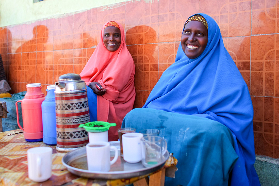
Women selling tea in Buur-Hakba, a city in southwestern Somalia some 180 kilometres inland from the coastal capital of Mogadishu.
Photo credit Stuart Price, UN Photo

SOMALIA: OVERVIEW
Region: Eastern Africa
Population: 19 million | 1.3% of Africa’s population
Population density: 30.3 people per square kilometre | 0.6 x African average
Surface area: 637,657 square kilometres | 2.2% of Africa
Capital city: Mogadishu
SOMALIA: ECONOMY
World Bank classification: Low income
Currency: Somali shilling (SOS)
Gross domestic product (GDP): $10.4 billion | 0.4% of Africa’s GDP
Average GDP per person: $592.10 | 0.3 x African average
Agriculture: 60.2% of economy
Industry: 7.4% of economy
Services and other: 32.5% of economy
Labour force unemployment rate: 19.1%
Share of women in the labour force: 21.2%
Share of men in the labour force: 47.3%
SOMALIA: INTERNATIONAL TRADE
Major export partners (share of exports): United Arab Emirates 44. 3% | Oman 33.4% | Saudi Arabia 8.4%
Major import partners (share of imports): United Arab Emirates 33. 7% | China 19.1% | India 16.1%
Exports value: $833 million | 0.1% of Africa’s exports
Imports value: $4 billion | 0.6% of Africa’s imports
SOMALIA: INDICATORS
Income inequality – Gini index: 55% (2016) | Africa rank: 22nd out of 54 (higher score & rank = more inequality)
Human development index: Low | Score 0.404 | Africa rank: 53rd out of 54 | Global rank: 192nd out of 193
Inequality-adjusted human development index: Score 0.229 | Africa rank: 50th out of 51 | Global rank: 168th out of 169
Gender inequality index: Score 0.675 | Africa rank: 48th out of 49 | Global rank: 170th out of 172 (higher score = less equality; higher rank = more equality)
LGBT equality index: 1% | Africa rank: 54th out of 54
Urbanisation: 45.6% of inhabitants live in cities
Government spending on education: 0% of GDP
Women in national parliament hold 19.6% of seats
Internet access: 27.6% of inhabitants use the internet
COUNTRY: ENVIRONMENT
Forests: 9.4% of land area
Annual carbon dioxide (CO2) emissions: 0.6 million tonnes | 0.05% of African total | 0.002% of world total
CO2 emissions per person: 0.3 tonnes | 0.3 x African average | 0.007 x world average
SOMALIA: HISTORY & HERITAGE
Official languages: Somali, Arabic
Colonised by: Britain 1884-1960 | Italy 1889-1941 | UN trust territory 1946-1960
Independence: 1960 – from Britain and UN
South Africa

Canola fields and the South African town of Clanwilliam in the Olifants River valley region of the Cederberg. Cape Town’s Table Mountain can be seen in the distance, 200 kilometres to the south.
Photo credit Damien du Toit
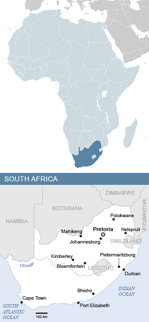
SOUTH AFRICA: OVERVIEW
Region: Southern Africa
Population: 64 million | 4.2% of Africa’s population
Population density: 52.4 people per square kilometre | 1 x African average
Surface area: 1,221,037 square kilometres | 4.1% of Africa
Capital city: Pretoria
SOUTH AFRICA: ECONOMY
World Bank classification: Upper middle income
Currency: rand (ZAR)
Gross domestic product (GDP): $405.3 billion | 14.1% of Africa’s GDP
Average GDP per person: $6,766.50 | 3.4 x African average
Agriculture: 3.2% of economy
Industry: 27.5% of economy
Services and other: 69.4% of economy
Labour force unemployment rate: 28.6%
Share of women in the labour force: 52.2%
Share of men in the labour force: 64.1%
SOUTH AFRICA: INTERNATIONAL TRADE
Major export partners (share of exports): China 11.3% | United States 7.5% | Germany 6.8%
Major import partners (share of imports): China 20.5% | United States 8.6% | Germany 8.1%
Exports value: $110.6 billion | 19% of Africa’s exports
Imports value: $107.1 billion | 15.6% of Africa’s imports
SOUTH AFRICA: INDICATORS
Income inequality – Gini index: 67% (2017) | Africa rank: 1st out of 54 (higher score & rank = more inequality)
Human development index: High | Score 0.741 | Africa rank: 6th out of 54 | Global rank: 106th out of 193
Inequality-adjusted human development index: Score 0.476 | Africa rank: 11th out of 51 | Global rank: 119th out of 169
Gender inequality index: Score 0.388 | Africa rank: 5th out of 49 | Global rank: 95th out of 172 (higher score = less equality; higher rank = more equality)
LGBT equality index: 67% | Africa rank: 2nd out of 54 | Legal freedoms: 77% | Public opinion: 58%
Urbanisation: 66.9% of inhabitants live in cities
Government spending on education: 6.6% of GDP
Women in national parliament hold 46% of seats
Internet access: 74.7% of inhabitants use the internet
SOUTH AFRICA: ENVIRONMENT
Forests: 14% of land area
Annual carbon dioxide (CO2) emissions: 434.2 million tonnes | 33.4% of African total | 1.3% of world total
CO2 emissions per person: 7.3 tonnes | 8.1 x African average | 1.7 x world average
SOUTH AFRICA: HISTORY & HERITAGE
Official languages: Afrikaans, English, isiNdebele, isiXhosa, isiZulu, Sesotho sa Leboa, Sesotho, Setswana, siSwati, Tshivenda, Xitsonga
Colonised by: Netherlands 1562-1795 | Britain 1795-1961 | internal white minority 1961-1994
Independence: 1961 – from Britain | 1994 – first democratic elections
World Heritage Sites: South Africa has nine Unesco World Heritage Sites. Five are cultural, three natural, and one of mixed cultural and natural heritage. The five cultural sites are the ǂKhomani Cultural Landscape, the Mapungubwe Cultural Landscape, the Richtersveld Cultural and Botanical Landscape, Robben Island, and the country’s rich fossil hominid sites. The three natural sites are the Cape Floral Region, iSimangaliso Wetland Park and the ancient Vredefort Dome meteor impact site. Finally, the uKhahlamba Drakensberg Mountains are valued for both their natural beauty and the rich cultural heritage of San Bushman paintings found in their caves and rock shelters.
South Sudan

The Kush Dance Group performs at the Comedy for Peace event at the Nyakuron Cultural Centre in Juba on 23 April 2017. The event featured the best of South Sudanese comedians and musicians, including Emmanuel Kembe, Woklii, Feel Free, Lotole Captain Eddy and Kon Kuol Kon.
Photo credit Amanda Voisard, UN Photo

SOUTH SUDAN: OVERVIEW
Region: Eastern Africa
Population: 11.9 million | 0.8% of Africa’s population
Population density: 21.2 people per square kilometre | 0.4 x African average
Surface area*: 646,883 square kilometres | 2.2% of Africa
Capital city: Juba
SOUTH SUDAN: ECONOMY
World Bank classification: Low income
Currency: South Sudanese pound (SSP)
Gross domestic product (GDP): $4.6 billion | 0.2% of Africa’s GDP
Average GDP per person: $423.00 | 0.2 x African average
Agriculture: 2.8% of economy
Industry: 62.5% of economy
Services and other: 34.7% of economy
Labour force unemployment rate: 11.8%
Share of women in the labour force: 70.4%
Share of men in the labour force: 71.2%
SOUTH SUDAN: INTERNATIONAL TRADE
Major export partners (share of exports): China 66.8% | Singapore 11.3% | United Arab Emirates 10%
Major import partners (share of imports): Uganda 40.5% | United Arab Emirates 20.5% | Kenya 12.2%
Exports value: $631 million | 0.1% of Africa’s exports
Imports value: $1.3 billion | 0.2% of Africa’s imports
SOUTH SUDAN: INDICATORS
Income inequality – Gini index: 58% (2017) | Africa rank: 12nd out of 54 (higher score & rank = more inequality)
Human development index: Low | Score 0.388 | Africa rank: 54th out of 54 | Global rank: 193rd out of 193
Inequality-adjusted human development index: Score 0.226 | Africa rank: 51st out of 51 | Global rank: 169th out of 169
LGBT equality index: 8% | Africa rank: 46th out of 54
Urbanisation: 19.9% of inhabitants live in cities
Government spending on education: 1.6% of GDP
Women in national parliament hold 32.4% of seats
Internet access: 12.1% of inhabitants use the internet
SOUTH SUDAN: ENVIRONMENT
Forests: 11.3% of land area
Annual carbon dioxide (CO2) emissions: 1.8 million tonnes | 0.1% of African total | 0.005% of world total
CO2 emissions per person: 0.2 tonnes | 0.2 x African average | 0.05 x world average
SOUTH SUDAN: HISTORY & HERITAGE
Official languages: English
Other languages: Bari, Dinka, Luo, Murle, Nuer, Zande and some 60 others
Colonised by: Britain 1889-1956 | Sudan 1956-2011
Independence: 1956 – from Britain | 2011 – from Sudan
Sudan
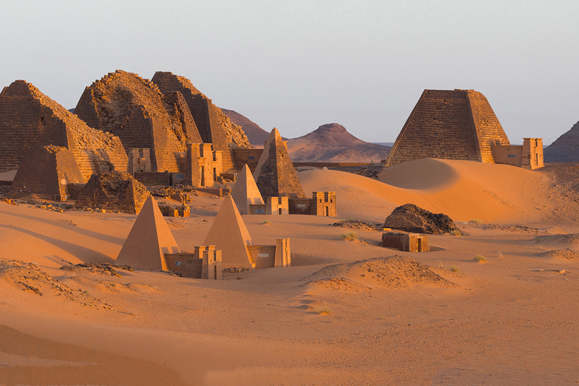
The pyramids of Kushite rulers at Meroë, an ancient city on the banks of the Nile River in eastern Sudan. Meroë was the capital of the Kingdom of Kush, one of the earliest and largest states in precolonial sub-Saharan Africa, which flourished from around 1,000 BCE to 350 CE.
Photo credit Valerian Guillot

SUDAN: OVERVIEW
Region: Northern Africa
Population: 50.4 million | 3.3% of Africa’s population
Population density: 28.6 people per square kilometre | 0.6 x African average
Capital city: Khartoum
SUDAN: ECONOMY
World Bank classification: Low income
Currency: Sudanese pound (SDG)
Gross domestic product (GDP): $36.7 billion | 1.3% of Africa’s GDP
Average GDP per person: $783.60 | 0.4 x African average
Agriculture: 20.1% of economy
Industry: 21.7% of economy
Services and other: 58.1% of economy
Labour force unemployment rate: 20.8%
Share of women in the labour force: 28%
Share of men in the labour force: 67.6%
SUDAN: INTERNATIONAL TRADE
Major export partners (share of exports): United Arab Emirates 43. 6% | China 13.9% | Malaysia 7.4%
Major import partners (share of imports): United Arab Emirates 19. 3% | India 17.7% | Saudi Arabia 15%
Exports value: $11.7 billion | 2% of Africa’s exports
Imports value: $5.8 billion | 0.8% of Africa’s imports
SUDAN: INDICATORS
Income inequality – Gini index: 53.8% (2014) | Africa rank: 27th out of 54 (higher score & rank = more inequality)
Human development index: Low | Score 0.511 | Africa rank: 39th out of 54 | Global rank: 176th out of 193
Inequality-adjusted human development index: Score 0.328 | Africa rank: 36th out of 51 | Global rank: 152nd out of 169
Gender inequality index: Score 0.588 | Africa rank: 38th out of 49 | Global rank: 158th out of 172 (higher score = less equality; higher rank = more equality)
LGBT equality index: 14% | Africa rank: 30th out of 54 | Legal freedoms: 9% | Public opinion: 19%
Urbanisation: 34.9% of inhabitants live in cities
:% of GDP
Women in national parliament hold 27.7% of seats
Internet access: 28.7% of inhabitants use the internet
SUDAN: ENVIRONMENT
Forests: 9.7% of land area
Annual carbon dioxide (CO2) emissions: 20.6 million tonnes | 1.6% of African total | 0.06% of world total
CO2 emissions per person: 0.4 tonnes | 0.4 x African average | 0.1 x world average
SUDAN: HISTORY & HERITAGE
Official languages: Arabic, English
Colonised by: Egypt 1820-1885 | Britain 1899-1956
Independence: 1956 – from Britain
World Heritage Site: The archaeological sites of Gebel Barkal and the Napatan region in the Nile valley, testimony to the Napatan (900 to 270 BC) and Meroitic (270 BC to 350 AD) cultures of the second kingdom of Kush.
Tanzania

The waterfront skyline of Dar es Salaam, Tanzania’s largest city. With 4.4-million people, Dar is the biggest city in East Africa and home to the largest Swahili-speaking population in the world. It was founded in 1865 by Sultan Majid bin Said of Zanzibar, who gave the city its name. Dar es Salaam means “place of peace” in Arabic.
Photo credit David Stanley

TANZANIA: OVERVIEW
Region: Eastern Africa
Population: 68.6 million | 4.5% of Africa’s population
Population density: 77.4 people per square kilometre | 1.5 x African average
Surface area: 947,303 square kilometres | 3.2% of Africa
Capital city: Dodoma
TANZANIA: ECONOMY
World Bank classification: Lower middle income
Currency: Tanzanian shilling (TZS)
Gross domestic product (GDP): $73.5 billion | 2.6% of Africa’s GDP
Average GDP per person: $1,153.80 | 0.6 x African average
Agriculture: 28.4% of economy
Industry: 33.5% of economy
Services and other: 38.2% of economy
Labour force unemployment rate: 2.5%
Share of women in the labour force: 77.2%
Share of men in the labour force: 86%
TANZANIA: INTERNATIONAL TRADE
Major export partners (share of exports): India 21.4% | South Africa 15.4% | United Arab Emirates 9.4%
Major import partners (share of imports): China 27.5% | India 12.9% | United Arab Emirates 9.4%
Exports value: $7.3 billion | 1.2% of Africa’s exports
Imports value: $15.1 billion | 2.2% of Africa’s imports
TANZANIA: INDICATORS
Income inequality – Gini index: 54.8% (2018) | Africa rank: 23rd out of 54 (higher score & rank = more inequality)
Human development index: Medium | Score 0.555 | Africa rank: 30th out of 54 | Global rank: 165th out of 193
Inequality-adjusted human development index: Score 0.391 | Africa rank: 20th out of 51 | Global rank: 134th out of 169
Gender inequality index: Score 0.504 | Africa rank: 20th out of 49 | Global rank: 134th out of 172 (higher score = less equality; higher rank = more equality)
LGBT equality index: 14% | Africa rank: 30th out of 54 | Legal freedoms: 13% | Public opinion: 14%
Urbanisation: 34.5% of inhabitants live in cities
Government spending on education: 3.4% of GDP
Women in national parliament hold 37.4% of seats
Internet access: 31.9% of inhabitants use the internet
TANZANIA: ENVIRONMENT
Forests: 51.1% of land area
Annual carbon dioxide (CO2) emissions: 15.9 million tonnes | 1.2% of African total | 0.05% of world total
CO2 emissions per person: 0.2 tonnes | 0.2 x African average | 0.05 x world average
TANZANIA: HISTORY & HERITAGE
Languages: Swahili, English
Colonised by: Germany 1885-1919 | Britain 1920-1963
Independence: Tanganyika 1961 – from Britain | Zanzibar and Pemba 1963 – from Britain | Union 1964
World Heritage Site: Kilimanjaro National Park
Togo

An African Cup of Nations qualifier football match between Togo and Gabon at the Stade de Kégué in Lomé, the Togolese capital, on 14 October 2012. Togo won by two goals to one.
Photo credit Panoramas

TOGO: OVERVIEW
Region: Western Africa
Population: 9.5 million | 0.6% of Africa’s population
Population density: 174.9 people per square kilometre | 3.4 x African average
Surface area: 56,785 square kilometres | 0.2% of Africa
Capital city: Lomé
TOGO: ECONOMY
World Bank classification: Low income
Currency: CFA franc, Central Bank of West African States (XOF)
Gross domestic product (GDP): $8.1 billion | 0.3% of Africa’s GDP
Average GDP per person: $913.90 | 0.5 x African average
Agriculture: 20.6% of economy
Industry: 22.6% of economy
Services and other: 56.7% of economy
Labour force unemployment rate: 3.7%
Share of women in the labour force: 56.2%
Share of men in the labour force: 59.7%
TOGO: INTERNATIONAL TRADE
Major export partners (share of exports): India 22.5% | Burkina Faso 9.2% | Benin 8.4%
Major import partners (share of imports): China 19% | France 9% | India 7.9%
Exports value: $1.5 billion | 0.3% of Africa’s exports
Imports value: $3.0 billion | 0.4% of Africa’s imports
TOGO: INDICATORS
Income inequality – Gini index: 52.9% (2022) | Africa rank: 31st out of 54 (higher score & rank = more inequality)
Human development index: Medium | Score 0.571 | Africa rank: 27th out of 54 | Global rank: 161st out of 193
Inequality-adjusted human development index: Score 0.363 | Africa rank: 24th out of 51 | Global rank: 139th out of 169
Gender inequality index: Score 0.564 | Africa rank: 31st out of 49 | Global rank: 150th out of 172 (higher score = less equality; higher rank = more equality)
LGBT equality index: 9% | Africa rank: 44th out of 54 | Legal freedoms: 6% | Public opinion: 12%
Urbanisation: 42.2% of inhabitants live in cities
Government spending on education: 4.2% of GDP
Women in national parliament hold 18.9% of seats
Internet access: 37.6% of inhabitants use the internet
TOGO: ENVIRONMENT
Forests: 22.2% of land area
Annual carbon dioxide (CO2) emissions: 1.8 million tonnes | 0.1% of African total | 0.005% of world total
CO2 emissions per person: 0.2 tonnes | 0.2 x African average | 0.05 x world average
TOGO: HISTORY & HERITAGE
Official language: French
Other languages: Ewe, Kabiyé, Gbe languages, Kotocoli
Colonised by: Germany 1884-1916 | France 1916-1960
Independence: 1960 – from France
World Heritage Site: Koutammakou, the land of the Batammariba people, whose remarkable mud tower-houses (takienta) have become a symbol of Togo.
Tunisia
The Demna Baptistry, from the sixth century CE. This large Christian baptismal font was designed to allow the whole body of the baptised person to be submerged in water. Discovered in Demna, Jbal Lahmar, near Tunis in Tunisia, it is one of the finest early Christian mosaics found in Africa and in the whole of the ancient Roman world.
Photo credit Dennis Jarvis

TUNISIA: OVERVIEW
Region: Northern Africa
Population: 12.3 million | 0.8% of Africa’s population
Population density: 79 people per square kilometre | 1.5 x African average
Surface area: 163,610 square kilometres | 0.6% of Africa
Capital city: Tunis
TUNISIA: ECONOMY
World Bank classification: Lower middle income
Currency: Tunisian dinar (TND)
Gross domestic product (GDP): $46.2 billion | 1.6% of Africa’s GDP
Average GDP per person: $3,737.50 | 1.9 x African average
Agriculture: 10.5% of economy
Industry: 24.8% of economy
Services and other: 64.7% of economy
Labour force unemployment rate: 17.7%
Share of women in the labour force: 26.9%
Share of men in the labour force: 68.9%
TUNISIA: INTERNATIONAL TRADE
Major export partners (share of exports): France 22.3%, Italy 16.8%, Germany 12.9%
Major import partners (share of imports): Italy 14.6%, China 10.5%, France 10.4%
Exports value: $20.3 billion | 3.5% of Africa’s exports
Imports value: $25.9 billion | 3.8% of Africa’s imports
TUNISIA: INDICATORS
Income inequality – Gini index: 40.9% (2022) | Africa rank: 48th out of 54 (higher score & rank = more inequality)
Human development index: High | Score 0.746 | Africa rank: 5th out of 54 | Global rank: 105th out of 193
Inequality-adjusted human development index: Score 0.595 | Africa rank: 4th out of 51 | Global rank: 93rd out of 169
Gender inequality index: Score 0.238 | Africa rank: 1st out of 49 | Global rank: 62nd out of 172 (higher score = less equality; higher rank = more equality)
LGBT equality index: 14% | Africa rank: 30th out of 54 | Legal freedoms: 13% | Public opinion: 15%
Women in national parliament hold 15.7% of seats
Urbanisation: 69.3% of inhabitants live in cities (2020)
Government spending on education: 6.2 % of GDP (2015)
Internet access: 73.8% of inhabitants use the internet
TUNISIA: ENVIRONMENT
Forests: 4.5% of land area
Annual carbon dioxide (CO2) emissions: 26.9 million tonnes | 2.1% of African total | 0.08% of world total
CO2 emissions per person: 2.2 tonnes | 2.4 x African average | 0.5 x world average
TUNISIA: HISTORY & HERITAGE
Official languages: Arabic
Other languages: Berber, French
Colonised by: France 1881-1956
Independence: 1956 – from France
World Heritage Site: The Amphitheatre of El Jem, built during the third century.
Uganda
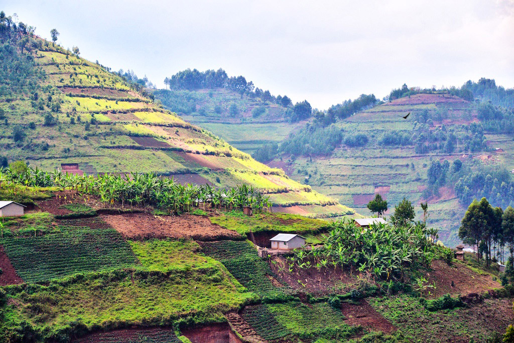
The fields of small-scale farmers blanket hillsides in Kikungiri near the town of Kabale in southeastern Uganda.
Photo credit Rod Waddington
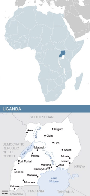
UGANDA: OVERVIEW
Region: Eastern Africa
Population: 50 million | 3.3% of Africa’s population
Population density: 250.3 people per square kilometre | 4.9 x African average
Surface area: 241,550 square kilometres | 0.8% of Africa
Capital city: Kampala
UGANDA: ECONOMY
World Bank classification: Low income
Currency: Uganda shilling (UGX)
Gross domestic product (GDP): $48.2 billion | 1.7% of Africa’s GDP
Average GDP per person: $1,021.00 | 0.5 x African average
Agriculture: 27.1% of economy
Industry: 28.2% of economy
Services and other: 44.7% of economy
Labour force unemployment rate: 2.8%
Share of women in the labour force: 67.6%
Share of men in the labour force: 72.3%
UGANDA: INTERNATIONAL TRADE
Major export partners (share of exports): United Arab Emirates 26.8% | Kenya 13.3% | South Sudan 12.2%
Major import partners (share of imports): China 18.2% | India 11.6% | Tanzania 9%
Exports value: $5.6 billion | 1% of Africa’s exports
Imports value: $12.6 billion | 1.8% of Africa’s imports
UGANDA: INDICATORS
Income inequality – Gini index: 56.8% (2020) | Africa rank: 17th out of 54 (higher score & rank = more inequality)
Human development index: Medium | Score 0.582 | Africa rank: 24th out of 54 | Global rank: 157th out of 193
Inequality-adjusted human development index: Score 0.4 | Africa rank: 17th out of 51 | Global rank: 131st out of 169
Gender inequality index: Score 0.524 | Africa rank: 25th out of 49 | Global rank: 141st out of 172 (higher score = less equality; higher rank = more equality)
LGBT equality index: 9% | Africa rank: 44th out of 54 | Legal freedoms: 1% | Public opinion: 18%
Urbanisation: 24.4% of inhabitants live in cities
Government spending on education: 2.6% of GDP
Women in national parliament hold 33.9% of seats
Internet access: 10% of inhabitants use the internet
UGANDA: ENVIRONMENT
Forests: 11.5% of land area
Annual carbon dioxide (CO2) emissions: 5.7 million tonnes | 0.4% of African total | 0.02% of world total
CO2 emissions per person: 0.1 tonnes | 0.1 x African average | 0.02 x world average
UGANDA: HISTORY & HERITAGE
Official languages: English and Swahili
Other languages: Around 40 other languages
Colonised by: Britain 1894-1962
Independence: 1962 – from Britain
World Heritage Site: The Tombs of Buganda Kings at Kasubi, the former palace of the Kabakas of Buganda, built in 1882 and converted into a royal burial ground in 1884.
WESTERN SAHARA: OVERVIEW
Region: Northern Africa
Population: 590,000 | 0.04% of Africa’s population
Population density: 2.2 people per square kilometre | 0.04 x African average
Surface area: 266,000 square kilometres | 0.9% of Africa
Capital city: El Aaiún
WESTERN SAHARA: ECONOMY
Currency: Moroccan dirham (MAD)
Labour force unemployment rate: 8.1%
Share of women in the labour force: 31%
Share of men in the labour force: 79.5%
WESTERN SAHARA: INDICATORS & ENVIRONMENT
Urbanisation: 86.8% of inhabitants live in cities
Forests: 2.5% of land area
WESTERN SAHARA: HISTORY & HERITAGE
Languages: Hassaniya Arabic, Moroccan Arabic, Berber, Spanish
Colonised by: Spain 1884-1975 | Morocco 1975-present
Zambia

An aerial view of the massive Zambezi River – which gives Zambia its name – and the Victoria Falls. The waterfall, named Mosi-oa-Tunya or “the smoke that thunders” in Tokaleya Tonga, is said to be the biggest in the world. Its combined width of 1,708 metres and height of 108 metres result in the world’s largest sheet of falling water. Here Zambia’s border with Zimbabwe runs along the middle of the river, with Zimbabwe on the left and Zambia on the right. The steel Victoria Falls bridge at lower left is a border post between the countries.
Photo credit Dsopfe

ZAMBIA: OVERVIEW
Region: Eastern Africa
Population: 21.3 million | 1.4% of Africa’s population
Population density: 28.7 people per square kilometre | 0.6 x African average
Surface area: 752,612 square kilometres | 2.5% of Africa
Capital city: Lusaka
ZAMBIA: ECONOMY
World Bank classification: Lower middle income
Currency: Zambian kwacha (ZMW)
Gross domestic product (GDP): $29.1 billion | 1% of Africa’s GDP
Average GDP per person: $1,455.50 | 0.7 x African average
Agriculture: 3.3% of economy
Industry: 37.6% of economy
Services and other: 59.1% of economy
Labour force unemployment rate: 4.2%
Share of women in the labour force: 52.1%
Share of men in the labour force: 67.2%
ZAMBIA: INTERNATIONAL TRADE
Major export partners (share of exports): Switzerland 41.4% | China 17.7% | Democratic Republic of the Congo 15.4%
Major import partners (share of imports): South Africa 25.8% | China 16.2% | United Arab Emirates 8.2%
Exports value: $10.4 billion | 1.8% of Africa’s exports
Imports value: $10.1 billion | 1.5% of Africa’s imports
ZAMBIA: INDICATORS
Income inequality – Gini index: 63.1% (2022) | Africa rank: 4th out of 54 (higher score & rank = more inequality)
Human development index: Medium | Score 0.595 | Africa rank: 22nd out of 54 | Global rank: 154th out of 193
Inequality-adjusted human development index: Score 0.361 | Africa rank: 25th out of 51 | Global rank: 140th out of 169
Gender inequality index: Score 0.524 | Africa rank: 25th out of 49 | Global rank: 141st out of 172 (higher score = less equality; higher rank = more equality)
LGBT equality index: 8% | Africa rank: 46th out of 54 | Legal freedoms: 9% | Public opinion: 8%
Urbanisation: 44.1% of inhabitants live in cities
Government spending on education: 3.9% of GDP
Women in national parliament hold 15% of seats
Internet access: 31.2% of inhabitants use the internet
ZAMBIA: ENVIRONMENT
Forests: 60% of land area
Annual carbon dioxide (CO2) emissions: 7 million tonnes | 0.5% of African total | 0.02% of world total
CO2 emissions per person: 0.4 tonnes | 0.4 x African average | 0.1 x world average
ZAMBIA: HISTORY & HERITAGE
Official language: English
Other languages: Nyanja, Bemba, Chewa, Lozi, Kaonde, Lunda, Tonga, Luvale and around 60 others
Colonised by: Britain
Independence: 1964 – from Britain
World Heritage Site: The Victoria Falls – Mosi-oa-Tunya, “the smoke that thunders” – is the world’s largest sheet of falling water, significant for the beauty of its spray, mist and permanent rainbows.
Zimbabwe

Inside the citadel of Great Zimbabwe, the ancient Shona city in the southeastern province of Masvingo. The 722-hectare city was the capital of the medieval Kingdom of Zimbabwe, which flourished for over two centuries from 1220 to 1450.
Photo credit Amanda Anderson
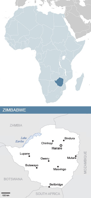
ZIMBABWE: OVERVIEW
Region: Eastern Africa
Population: 16.6 million | 1.1% of Africa’s population
Population density: 43 people per square kilometre | 0.8 x African average
Surface area: 390,757 square kilometres | 1.3% of Africa
Capital city: Harare
ZIMBABWE: ECONOMY
World Bank classification: Lower middle income
Currency: Zimbabwe dollar (ZWL)
Gross domestic product (GDP): $26.4 billion | 0.9% of Africa’s GDP
Average GDP per person: $1,618.70 | 0.8 x African average
Agriculture: 8.1% of economy
Industry: 44.9% of economy
Services and other: 47% of economy
Labour force unemployment rate: 9%
Share of women in the labour force: 60.6%
Share of men in the labour force: 72.5%
ZIMBABWE: INTERNATIONAL TRADE
Major export partners (share of exports): South Africa 30.9% | United Arab Emirates 26.4% | China 17.7%
Major import partners (share of imports): South Africa 38% | China 14.9% | Bahamas 5.1%
Exports value: $7.2 billion | 1.2% of Africa’s exports
Imports value: $9.2 billion | 1.3% of Africa’s imports
ZIMBABWE: INDICATORS
Income inequality – Gini index: 62.8% (2019) | Africa rank: 6th out of 54 (higher score & rank = more inequality)
Human development index: Medium | Score 0.598 | Africa rank: 21st out of 54 | Global rank: 153rd out of 193
Inequality-adjusted human development index: Score 0.406 | Africa rank: 16th out of 51 | Global rank: 130th out of 169
Gender inequality index: Score 0.519 | Africa rank: 24th out of 49 | Global rank: 140th out of 172 (higher score = less equality; higher rank = more equality)
LGBT equality index: 13% | Africa rank: 35th out of 54 | Legal freedoms: 16% | Public opinion: 10%
Urbanisation: 32.2% of inhabitants live in cities
Government spending on education: 2.1% of GDP
Women in national parliament hold 28.8% of seats
Internet access: 32.6% of inhabitants use the internet
ZIMBABWE: ENVIRONMENT
Forests: 45% of land area
Annual carbon dioxide (CO2) emissions: 9.7 million tonnes | 0.7% of African total | 0.03% of world total
CO2 emissions per person: 0.6 tonnes | 0.7 x African average | 0.1 x world average
ZIMBABWE: HISTORY & HERITAGE
Official languages: Chishona, isiNdebele, English and 13 others
Colonised by: Britain 1888-1964 | internal (white minority) 1964-1980
Independence: 1965 – from Britain (declared) | 1980 – first democratic elections
World Heritage Site: The ruins of Great Zimbabwe are a unique testimony to the Bantu civilization of the Shona between the 11th and 15th centuries.
Sources & notes
ALL SOURCES
Unless otherwise stated, information sourced from the World Statistics Pocketbook 2024, UN Statistics Division.
Other sources:
- FAOSTAT, Food and Agriculture Organization of the UN
- Observatory of Economic Complexity
- International Trade Centre – Trade Map
- Human Development Report 2025, UN Development Programme
- Unesco World Heritage Centre
- CIA World Fact Book
- Wikimedia Commons
- Flickr Creative Commons
MAPS & PHOTOS
- Africa maps adapted from maps by Alvaro1984 18, Wikimedia Commons
- Country maps adapted from maps by ReliefWeb, a service provided by the UN Office for the Coordination of Humanitarian Affairs
- Photos: See credit in captions.
ECONOMY
- World Bank income classification 2024: explanation
- World Bank income classification 2024: data
INDICATORS
- Income inequality – Gini index: explanation
- Income inequality – Gini index: UNU WIDER World Income Inequality Database
- Human development index, UNDP World Development Report 2025
- Inequality-adjusted human development index, UNDP World Development Report 2025
- Gender inequality index, UNDP World Development Report 2025
- Equaldex LGBT equality index in Africa
ENVIRONMENT
- Forests & CO2 emissions: FAOSTAT, Food and Agriculture Organization of the UN
HISTORY & HERITAGE
- Languages: CIA World Fact Book
- World Heritage Site: Unesco World Heritage Centre
Researched, written and designed by Mary Alexander. Updated December 2025.
Comments? Email mary1alexander@gmail.com
Categories: Africa
You must be logged in to post a comment.