South Africa has nine provinces, which vary in size from the small city region of Gauteng – home to more than a quarter of the population – to the great Northern Cape, by far the largest province but with the smallest population.
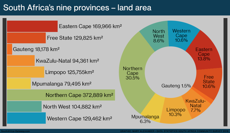
The land area of South Africa’s nine provinces, in order of size:
- Gauteng: 18,178 square kilometres (1.5% of total)
- Mpumalanga: 76,495 square kilometres (6.3%)
- KwaZulu-Natal: 94,361 square kilometres (7.7%)
- North West: 104,882 square kilometres (8.6%)
- Limpopo: 125,755 square kilometres (10.3%)
- Western Cape: 129,462 square kilometres (10.6%)
- Free State: 129,825 square kilometres (10.6%)
- Eastern Cape: 168,966 square kilometres (13.8%)
- Northern Cape: 372,889 square kilometres (30.5%)
- South Africa: 1,220,813 square kilometres (100%)
(Source: Statistics South Africa Community Survey 2016)

Find out more about South Africa’s provinces
- The nine provinces of South Africa
- Infographic: The population of South Africa’s provinces
- Infographic: Population density in South Africa’s provinces
- Animation: The economies of South Africa’s provinces
- Moving to the city: Provincial migration
- Animation: What languages are spoken in South Africa’s provinces?
- South Africa’s provinces and ‘homelands’ before 1996
Written and designed by Mary Alexander.
Updated 7 April 2018.
Comments? Email southafrica.gateway@gmail.com
More infographics
 |
 |
 |
 |
 |
 |

The graphics on this page are licensed under a Creative Commons Attribution 4.0 International Licence.
Categories: Infographics, The land
You must be logged in to post a comment.