South Africa has nine provinces, each with its own history, landscape, population, languages, economy, cities and government.

Images from South Africa’s nine provinces. An Nguni cow on a beach on the Wild Coast of the Eastern Cape. The Brandwag rock in the eastern Free State. Street art in the Maboneng Precinct in Johannesburg, Gauteng. The Durban harbour in KwaZulu-Natal. Entabeni game reserve in Limpopo. Traditional Ndebele domestic artwork in Mpumalanga. Quiver trees in the Northern Cape. Mining in North West. A view of Lion’s Head from the suburb of Bo-Kaap in Cape Town, Western Cape.
South Africa’s nine provinces are the Eastern Cape, the Free State, Gauteng, KwaZulu-Natal, Limpopo, Mpumalanga, the Northern Cape, North West and the Western Cape.

![]()
![]()
![]()
![]()
![]()
![]()
![]()
![]()
![]()
![]()
![]()
History
Before 1996, South Africa had four provinces: the Transvaal and Orange Free State – previously Boer republics – and Natal and the Cape, once British colonies.
In 1910 these four states were united into a single country, the Union of South Africa, under British rule. This became the Republic of South Africa in 1960, under apartheid rule.
In the 1970s and eighties, under the apartheid doctrine of “separate development”, the map of South Africa was gradually spattered with the odd outlines of the “homelands”.
These unsustainable states were set up on disjointed parcels of land with no economic value. Laws were passed to make black South Africans citizens of these barren regions, denying black people’s citizenship of South Africa as a whole.
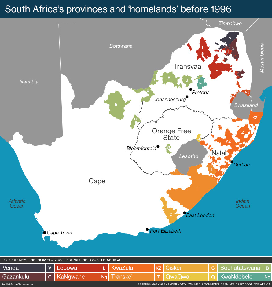 Click image for more information.
In 1996, under South Africa’s new democratic constitution, the homelands were dismantled, citizenship restored and South Africa consolidated into today’s nine provinces.
![]()
Land area of the provinces
There are vast differences in the size of the provinces, from the small and crowded city region of Gauteng to the vast and empty Northern Cape.

Data source: Statistics South Africa Census 2022
The land area of South Africa’s nine provinces, from smallest to largest:
- Gauteng: 18,178 square kilometres (1.5% of total)
- Mpumalanga: 76,495 square kilometres (6.3%)
- KwaZulu-Natal: 94,361 square kilometres (7.7%)
- North West: 104,882 square kilometres (8.6%)
- Limpopo: 125,755 square kilometres (10.3%)
- Western Cape: 129,462 square kilometres (10.6%)
- Free State: 129,825 square kilometres (10.6%)
- Eastern Cape: 168,966 square kilometres (13.8%)
- Northern Cape: 372,889 square kilometres (30.5%)
- South Africa: 1,220,813 square kilometres (100%)
READ MORE: How big is South Africa?
![]()
Population of the provinces
The population of the provinces also varies considerably. Gauteng, the smallest province, has the largest number of people living there – over a quarter of South Africa’s population. The Northern Cape, which takes up nearly a third of the country’s land area, has the smallest population: just over 2.2% of the national total.

In 2024 South Africa’s provincial populations, and their share of the total, were:
- Eastern Cape: 7,176,230 (11.4%)
- Free State: 3,044,050 (4.8%)
- Gauteng: 15,931,824 (25.3%)
- KwaZulu-Natal: 12,312,712 (19.5%)
- Limpopo: 6,402,594 (10.2%)
- Mpumalanga: 5,057,662 (8.%)
- Northern Cape: 1,372,943 (2.2%)
- North West: 4,155,303 (6.6%)
- Western Cape: 7,562,588 (12.%)
READ MORE: South Africa’s population
CENSUS COUNTS OF PROVINCIAL POPULATIONS
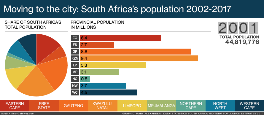
South Africa has held three censuses in its recent democratic history: in 1996, 2001 and 2011. Over those 15 years, the population of the provinces shifted.

Data: Statistics South Africa
Gauteng’s population grew dramatically, overtaking that of KwaZulu-Natal – which saw significant growth of its own. Limpopo, Mpumalanga, North West and the Western Cape also had notable increases in population. By contrast, the populations of the Eastern Cape, Free State and Northern Cape remained fairly static, as people migrated to other provinces.
READ MORE: Infographic: Census counts of South Africa’s population
![]()
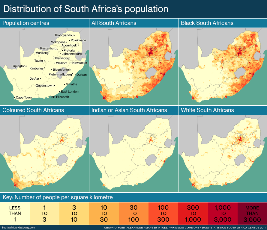
Population density in the provinces
The variation in land area and population among South Africa’s population translates into huge differences in population density, according to 2017 data. Gauteng has an average of 785 people per square kilometre, while the Northern Cape has only three people for each square kilometre.

Click image to learn more.
Population density in South Africa’s nine provinces in 2017, from smallest to largest:
- Northern Cape: 3 people per square kilometre
- Free State: 22 people per square kilometre
- North West: 37 people per square kilometre
- Eastern Cape: 38 people per square kilometre
- Limpopo: 46 people per square kilometre
- Western Cape: 50 people per square kilometre
- Mpumalanga: 58 people per square kilometre
- KwaZulu-Natal: 117 people per square kilometre
- Gauteng: 785 people per square kilometre

Map of population density in South Africa’s nine provinces.
READ MORE: South Africa’s population
![]()
Provincial migration
South Africans migrate away from poverty to where the jobs are, moving from poorer provinces to the richer ones.
Gauteng is South Africa’s wealthiest province, mostly a city region and the centre of the country’s economy. It has the largest population, constantly swelled by migration. The province’s net migration rate (the number of people moving in minus people moving out) was nearly a million between 2011 and 2016.
Click animation to view from the start. Data: Statistics South Africa mid-year population estimates 2017
The Eastern Cape is the poorest province. Between 2011 and 2016 nearly half a million of its people migrated to other provinces, while only 170 000 or so moved into the province.
READ MORE: South Africa’s population
![]()
Province and population group
There is also a wide variation in the racial composition of the different provinces’ populations.
Census 2011 figures reveal that black people were the majority population group in seven of the nine provinces, comprising from 75% to 97% of the provincial total. Yet they made up less than a third of the population in the Western Cape (26.7%) and under a half in the Northern Cape (46.5%).
Click image to learn more.
The distribution of a population group can reflect that people’s history in the country.
In 2011, coloured people were found mainly in the Western, Eastern and Northern Cape (respectively 61.1%, 12% and 10.7% of South Africa’s total coloured population). People of this group are largely descended from a mixture of slaves brought to what was then the Cape Colony, white immigrants to the colony, and indigenous Africans, particularly the Khoisan.
The majority (71.6%) of Indian/Asian people lived in KwaZulu-Natal in 2011. Many members of this group descend from indentured labourers brought to colonial Natal in the early 20th century to work on sugarcane plantations. Only 0.3% of Indians lived in the Free State (0.1% of the total Free State population), as they were forbidden by law to enter what was then the Orange Free State during the apartheid era.
Provincial distribution also reflects a group’s socioeconomic position. White people, the beneficiaries of the apartheid system, were largely found in the more developed and urbanised provinces of Gauteng (in 2011, 40.4% of the total white population, and 18.9% of the total Gauteng population) and the Western Cape (19.4% of the total white population, and 18.4% of the Western Cape population).
READ MORE: South Africa’s population
![]()
Languages of the provinces
There’s considerable variation in home languages between the provinces, according to Census 2011.

Click image to find out more.
IsiXhosa, for instance, is spoken by almost 80% of people in the Eastern Cape, while around 78% of those in KwaZulu-Natal speak isiZulu. IsiZulu is also the most common home language in Gauteng, but at a much smaller percentage. In the Western Cape and Northern Cape, Afrikaans comes into its own.
READ MORE: The languages of South Africa
The main languages in each province, according to Census 2011:
- Eastern Cape: isiXhosa 78.8%, Afrikaans 10.6%
- Free State: Sesotho 64.2%, Afrikaans 12.7%
- Gauteng: isiZulu 19.8%, English 13.3%, Afrikaans 12.4%, Sesotho 11.6%
- KwaZulu-Natal: isiZulu 77.8%, English 13.2%
- Limpopo: Sesotho 52.9%, Xitsonga 17%, Tshivenda 16.7%
- Mpumalanga: siSwati 27.7%, isiZulu 24.1%, Xitsonga 10.4%, isiNdebele 10.1%
- Northern Cape: Afrikaans 53.8%, Setswana 33.1%
- North West: Setswana 63.4%, Afrikaans 9%
- Western Cape: Afrikaans 49.7%, isiXhosa 24.7%, English 20.3%

Click image to learn more.
![]()
Economy of the provinces
Gauteng dominates almost all industries in South Africa, except agriculture and mining.

Click animation to see a static version, and to learn more.
In 2016 the main industries in each province were:
- Eastern Cape: government services 21%, trade, catering and accommodation 18%, finance 16%
- Free State: government services 15%, finance 14%, trade, catering and accommodation 13%
- Gauteng: finance 23%, government services 19%, manufacturing 14%
- KwaZulu-Natal: manufacturing 16%, finance 15%, government services 15%
- Limpopo: mining 25%, government services 18%, trade, catering and accommodation 13%
- Mpumalanga: mining 20%, trade, catering and accommodation 13%, manufacturing 13%
- Northern Cape: mining 19%, government services 15%, finance 12%
- North West: mining 30%, government services 12%, finance 12%
- Western Cape: finance 23%, trade, catering and accommodation 15%, manufacturing 14%
THE PROVINCE’S SHARE OF SOUTH AFRICA’S ECONOMY
Population size correlates with each province’s contribution to the national economy, with Gauteng having the biggest.
The tiny province punches way above its weight, making up 33.8% of South Africa’s gross domestic product in 2016 and around 5% of the GDP of Africa as a whole. Next is KwaZulu-Natal with 16%, followed by the Western Cape with 13.7%. These three provinces together contribute nearly two-thirds to total economy of South Africa.
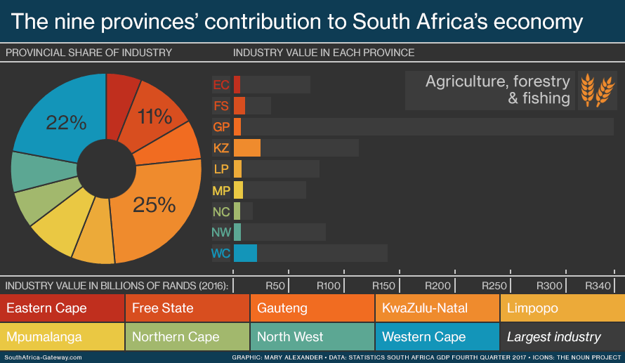
In 2016 the value of each province’s economy, and its share of the total GDP of South Africa, was:
- Northern Cape: R91 billion (2.1% of South Africa’s GDP)
- Free State: R218 billion (5%)
- North West: R280 billion (6.4%)
- Limpopo: R312 billion (7.2%)
- Mpumalanga: R324 billion (7.4%)
- Eastern Cape: R331 billion (7.6%)
- Western Cape: R596 billion (13.7%)
- KwaZulu-Natal: R692 billion (15.9%)
- Gauteng: R1.5 trillion (34.6%)
![]()
Government of the provinces

The eye-catching architecture of the Northern Cape Provincial Legislature in Galeshewe, Kimberley. Click image for a larger view. (Graeme Williams, MediaClub)
South Africa’s provinces are governed, in different ways, on a national, provincial and local level.
NATIONAL GOVERNMENT
On the national level, South Africa has two houses of parliament: the National Assembly, and the National Council of Provinces. The second exists to ensure that the interests of each province are protected in the laws passed by the National Assembly.
Each one of South Africa’s nine provinces sends 10 representatives to the National Council of Provinces. Six of these are permanent members of the council, and four are special delegates.
PROVINCIAL GOVERNMENT
Each province has its own provincial government.
The provincial legislature has the power to pass laws in certain limited areas. The legislature has between 30 and 80 members depending on the province’s portion of the national voters’ roll.
The premier – the head of government in the province – governs the province together with other “members of the executive council”, known as MECs. Each MEC has a specific responsibility, such as health, education, tourism and transport.
LOCAL GOVERNMENT
The nine provinces are each further divided into municipalities. Metropolitan municipalities are densely populated urban areas with major cities – such as Johannesburg or Durban – at their core. District municipalities are larger, less urban regions centred on one or more town or small city. District municipalities are further divided into local municipalities.
![]()
The cities of the provinces

Pietermaritzburg, the capital of KwaZulu-Natal. A contemporary statue of Mahatma Ghandi, an icon of resistance to colonial rule, stands against the heavily ornate facade of the Pietermaritzburg city hall, a building constructed during the era of the British Natal Colony. (E, CC BY-NC 2.0)
Each of the nine provinces has a provincial capital, the seat of provincial government. These are usually the largest city in the province – Johannesburg in Gauteng, for example, or Mahikeng in North West.
The exceptions are the Eastern Cape (Bhisho) and KwaZulu-Natal (Pietermaritzburg), which have smaller cities as their capitals for reasons of history. Cape Town in the Western Cape and Bloemfontein in the Free State also stand out for being both provincial capitals and two of the three capital cities of South Africa.
The provincial capitals and major cities of South Africa’s nine provinces are:
- Eastern Cape: Bhisho (capital) and Port Elizabeth (major city)
- Free State: Bloemfontein (capital and major city)
- Gauteng: Johannesburg (capital and major city)
- KwaZulu-Natal: Pietermaritzburg (capital) and Durban (major city)
- Limpopo: Polokwane (capital and major city)
- Mpumalanga: Mbombela (capital and major city) – also known as Nelspruit
- North West: Mahikeng (capital and major city) – formerly known as Mafeking, then as Mafikeng
- Northern Cape: Kimberley (capital and major city)
- Western Cape: Cape Town (capital and major city)

![]()
Sources
- Census South Africa public database
- Statistics South Africa Census 2022
- Statistics South Africa Census 2011
- Statistics South Africa Community Survey 2016
- Statistics South Africa mid-year population estimates 2017
- Statistics South Africa gross domestic product, fourth quarter 2017
- United Nations Statistics Division World Statistics Pocketbook 2017
- World Bank Open Data
- MediaClub
Researched, written and designed by Mary Alexander. Updated December 2025.
Comments? Email mary1alexander@gmail.com
Categories: The land
You must be logged in to post a comment.