The nine provinces of South Africa
South Africa has nine provinces, each with its own history, landscape, population, languages, economy, cities and government.
South Africa has nine provinces, each with its own history, landscape, population, languages, economy, cities and government.

Where are South Africa’s poorest places? Two maps find the patterns of poverty: one shows the share of households living in poverty in each municipality, the other the number of poor people living there. And an animation tries to make sense of the maps.

Before South Africa became a democracy in 1994, apartheid divided the country into four large provinces for white people, and 10 small unsustainable “homelands” for black people.
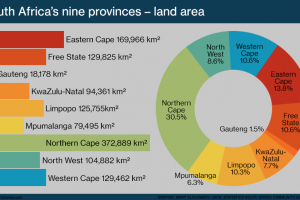
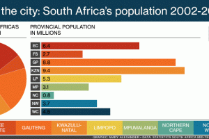
South Africa has nine provinces, which vary in size from the small city region of Gauteng – home to more than a quarter of the population – to the great Northern Cape, by far the largest province but with the smallest population.

Local government in the Eastern Cape is organised into eight major municipalities. Two are metropolitan, and the other six are district municipalities. The districts are further divided into 31 local municipalities.

Local government in the Free State is organised into five major municipalities. One is metropolitan, and the other four district municipalities. The districts are further divided into 19 local municipalities.

Local government in KwaZulu-Natal is organised into eight major municipalities. One is metropolitan, and the other 10 are district municipalities. The districts are further divided into 43 local municipalities.

Local government in Limpopo is organised into five district municipalities. The province also has 22 smaller local municipalities, each falling under one of the five district municipalities.

Local government in Mpumalanga is organised into three district municipalities. The province also has 17 smaller local municipalities, each falling under one of the district municipalities.

Local government in the Northern Cape is organised into five district municipalities. The province also has 26 smaller local municipalities, each falling under one of the five district municipalities.

Local government in North West is organised into four district municipalities. The province also has 18 smaller local municipalities, each falling under one of the four district municipalities.

Local government in the Western Cape is organised into six major municipalities. One is metropolitan, and five are district municipalities. The province also has 24 smaller local municipalities, each falling under one of the five districts.

The distribution of South Africa’s population groups reveals the country’s history. Find out more with these maps of where black, coloured, Indian and white South Africans live today, according to the 2011 census.
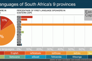
The home language of most people in KwaZulu-Natal is, unsurprisingly, isiZulu. In the Eastern Cape it’s isiXhosa. Around half the people of the Western Cape and Northern Cape speak Afrikaans. In Gauteng and Mpumalanga, no single language dominates.
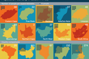
Gauteng, small but crowded, has an average of 785 people per square kilometre. The empty but enormous Northern Cape has a population density of only three people for each square kilometre.
South Africans migrate to where the jobs are. They move from poorer provinces to the richer ones, and from rural areas to the cities.

South Africa is twice the size of France and five times as big as the UK. With an area of 1.2-million square kilometres, it dwarfs the countries of Europe – except Russia – but doesn’t stand up to the giants of Asia and the Americas.

The Eastern Cape is South Africa’s poorest province, both in its percentage of poor households and the number of its people who live in poverty. The province with the smallest share of households in poverty is the Western Cape.
You must be logged in to post a comment.