Local government in the Eastern Cape is organised into eight major municipalities. Two are metropolitan, and the other six are district municipalities. The districts are further divided into 31 local municipalities.
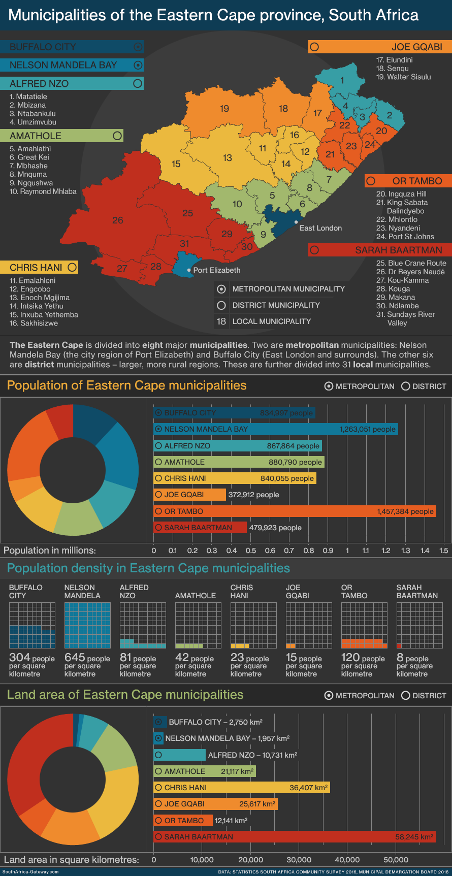
The Eastern Cape is divided into eight major municipalities.
Two are metropolitan municipalities: Nelson Mandela Bay (the city region of Gqeberha) and Buffalo City (East London and surrounds).
The other six are district municipalities – larger, more rural regions.
The district municipalities are further divided into 31 local municipalities.
Eastern Cape: Metropolitan and district municipalities
| Name | Type | Seat | Area | Population | Density |
|---|---|---|---|---|---|
| Administrative centre |
Square kilometres | Number of people |
People per square kilometre | ||
| Buffalo City | Metropolitan | East London | 2,750 | 834,997 | 304 |
| Nelson Mandela Bay | Metropolitan | Gqeberha | 1,957 | 1,263,051 | 645 |
| Alfred Nzo | District | Mount Ayliff | 10,731 | 867,864 | 81 |
| Amathole | District | East London | 21,117 | 880,790 | 42 |
| Chris Hani | District | Queenstown | 36,407 | 840,055 | 23 |
| Joe Gqabi | District | Barkly East | 25,617 | 372,912 | 15 |
| OR Tambo | District | Mthatha | 12,141 | 1,457,384 | 120 |
| Sarah Baartman | District | Port Elizabeth | 58,245 | 479,923 | 8 |
READ MORE ABOUT LOCAL GOVERNMENT:
- Local government in the Eastern Cape
- Local government in the Free State
- Local government in Gauteng
- Local government in KwaZulu-Natal
- Local government in Limpopo
- Local government in Mpumalanga
- Local government in the Northern Cape
- Local government in North West
- Local government in the Western Cape
READ MORE ABOUT SOUTH AFRICA’S PROVINCES:
- The nine provinces of South Africa
- The population of South Africa’s provinces
- The land area of South Africa’s provinces
- Gallery: The Eastern Cape
- Gallery: The Free State
- Infographic: The economies of South Africa’s nine provinces
- Infographic: Population density in South Africa’s provinces
- Infographic: What languages are spoken in South Africa’s provinces?
- The provinces and ‘homelands’ of South Africa before 1996
Data source: Statistics South Africa’s 2016 Community Survey
Thanks and credit to Htonl, who makes public-funded data available to the public and creates maps of South Africa you can’t find anywhere else.
Researched, written and designed by Mary Alexander.
Updated 10 March 2024.
Categories: Infographics, The land
You must be logged in to post a comment.